
Marsal (Moselle)
| Marsal | ||
|---|---|---|

|
|
|
| region | Grand Est | |
| Department | Moselle | |
| Arrondissement | Sarrebourg-Château-Salins | |
| Canton | Le Saulnois | |
| Community association | Saulnois | |
| Coordinates | 48 ° 47 ' N , 6 ° 37' E | |
| height | 199-307 m | |
| surface | 11.11 km 2 | |
| Residents | 282 (January 1, 2017) | |
| Population density | 25 inhabitants / km 2 | |
| Post Code | 57630 | |
| INSEE code | 57448 | |
 City gate Porte de France (exterior view) |
||

Marsal is a French commune with 282 inhabitants (as of January 1, 2017) in the Moselle department in the Grand Est region (until 2015 Lorraine ). It belongs to the Arrondissement of Sarrebourg-Château-Salins , the canton Le Saulnois and the Saulnois municipal association .
geography
The place is in the south of the Moselle department in Saulnois in the valley of the Seille in the basin of Dieuze , eight kilometers southeast of Château-Salins and four kilometers east of Moyenvic . The municipality is located in the Lorraine Regional Nature Park .
history
Marsal was first mentioned in 44 AD (under Emperor Claudius iJ). From the earliest times, salt production (the name Mar sal is derived from it) played a decisive role. In addition, there is the coinage attested since the Merovingian period. There was a monastery in the High Middle Ages. In 1005, Bishop Adalbero von Metz donated the church to the Benedictines of Neumünster near Ottweiler , and in 1222 the monastery was converted into a collegiate monastery (abolished in 1763). Marsal was first fortified in the 13th century. In 1593 the place fell to Lorraine, in 1663 it was taken over by France. Then let Louis XIV. By Vauban built a modern fortress. In the following years the place lost its importance. During the Franco-Prussian War (1870–1871) the fortress was captured on August 14, 1870 by the II Bavarian Army Corps after a short bombardment. After the war the fortification was razed. In the years 1915 to 1918 and from 1940 to 1944 Marsal carried the Germanized name Salzmar .
Population development
| year | 1962 | 1968 | 1975 | 1982 | 1990 | 1999 | 2007 | 2015 |
| Residents | 318 | 301 | 287 | 280 | 284 | 289 | 285 | 273 |
Culture and sights

The Briquetage de la Seille ( Briquetage de la Seille ) is an archaeological site from the Iron Age that was used until the 1st century. The ceramic vessels made there were used to extract salt. It is located on the Seille and extends over the municipal area of Marsal, Moyenvic and Vic-sur-Seille . The site was classified as a Monument historique (historical monument) in 1930 .
museum
- Salt Museum ( Musée départemental du sel ) on the upper floor of the city gate ( La Porte de France )
Buildings
- City gate La Porte de France
- City fortifications
- Church Saint-Léger , (from 12th century)
- Barracks
- arsenal
fortress
Despite the razing, the Vauban fortress has been preserved in impressive remains with star-shaped entrenchments and ramparts, along with porches. The salty springs can still be made out in the fortress moats.
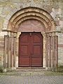
Church portal

arsenal
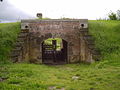
Postern of the city fortifications

City gate La Porte de France (interior view)


Viticulture
After the Saulnois winegrowing, which was abandoned in the First World War , celebrated a renaissance in neighboring Vic-sur-Seille at the beginning of the 1980s with the Gris de Vic (rosé wine based on the Gris de Toul ) , some vineyards on the southern slope of the Forêt were immediately followed de Bride replanted near Marsal (the wines are only marketed locally).
Web links
Individual evidence
- ^ Guides Gallimard (ed.): Lorraine . Gallimard, Paris 2002, ISBN 978-2-7424-0908-2 , pp. 49 . (French)
- ^ Marsal in the Base Mérimée des Ministère de la culture (French) Retrieved April 29, 2010