Ommeray
| Ommeray | ||
|---|---|---|

|
|
|
| region | Grand Est | |
| Department | Moselle | |
| Arrondissement | Sarrebourg-Château-Salins | |
| Canton | Le Saulnois | |
| Community association | Saulnois | |
| Coordinates | 48 ° 43 ' N , 6 ° 41' E | |
| height | 213-282 m | |
| surface | 10.12 km 2 | |
| Residents | 127 (January 1, 2017) | |
| Population density | 13 inhabitants / km 2 | |
| Post Code | 57810 | |
| INSEE code | 57524 | |
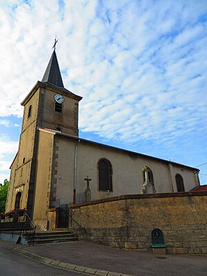
 Saint-Etienne church |
||
Ommeray is a French commune with 127 inhabitants (as of January 1, 2017) in the Moselle department in the Grand Est region (until 2015 Lorraine ). It belongs to the arrondissement of Sarrebourg-Château-Salins .
geography
Ommeray is located in the Saulnois , about 13 kilometers southeast of Vic-sur-Seille at an altitude between 213 and 282 m above sea level. The municipality covers 10.12 km². The municipality is part of the Lorraine Regional Nature Park .
history
1915-18 and 1940-44 the village had the Germanized name Ommerich .
Population development
| year | 1962 | 1968 | 1975 | 1982 | 1990 | 1999 | 2007 | 2015 |
| Residents | 180 | 155 | 131 | 122 | 117 | 110 | 101 | 115 |
Web links
Commons : Ommeray - collection of images, videos and audio files
