Jarny
| Jarny | ||
|---|---|---|

|
|
|
| region | Grand Est | |
| Department | Meurthe-et-Moselle | |
| Arrondissement | Briey | |
| Canton | Jarny (main town) | |
| Community association | Orne Lorraine Confluences | |
| Coordinates | 49 ° 10 ' N , 5 ° 53' E | |
| height | 185-236 m | |
| surface | 15.6 km 2 | |
| Residents | 8,283 (January 1, 2017) | |
| Population density | 531 inhabitants / km 2 | |
| Post Code | 54800 | |
| INSEE code | 54273 | |
| Website | http://www.jarny.fr/ | |
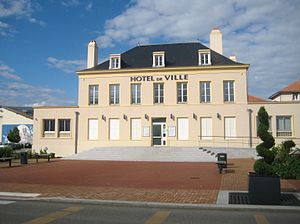
 Hotel de ville Jarny |
||
Jarny is a French commune with 8,283 inhabitants (as of January 1, 2017) in the Meurthe-et-Moselle department in the Grand Est region (until 2015 Lorraine ). It belongs to the Arrondissement of Briey .
geography
The municipality is located on the Orne , 20 kilometers west of Metz on the A4 autoroute , in the immediate vicinity of the municipality of Conflans-en-Jarnisy .
history
The community has existed since the Middle Ages. There were several iron mines here in the 20th century.
Population development
| year | 1962 | 1968 | 1975 | 1982 | 1990 | 1999 | 2009 | 2016 |
| Residents | 9224 | 9236 | 9287 | 8849 | 8401 | 8607 | 8535 | 8295 |
Attractions
- Castle Château de Moncel from the 13th century
- Church Saint-Maximin from the 13th century
- Saint-Joseph chapel from the 20th century
traffic
The railway lines Saint-Hilaire-au-Temple-Hagondange , Longuyon-Pagny-sur-Moselle and Conflans-Jarny-Metz meet at Conflans-Jarny station .
Town twinning
- since 1966: Linkenheim-Hochstetten (Baden-Württemberg)
- since 1969: Gröditz (Saxony)
Web links
Commons : Jarny - collection of images, videos and audio files
