
Hatrize
| Hatrize | ||
|---|---|---|

|
|
|
| region | Grand Est | |
| Department | Meurthe-et-Moselle | |
| Arrondissement | Briey | |
| Canton | Jarny | |
| Community association | Orne Lorraine Confluences | |
| Coordinates | 49 ° 12 ' N , 5 ° 54' E | |
| height | 182-236 m | |
| surface | 7.4 km 2 | |
| Residents | 769 (January 1, 2017) | |
| Population density | 104 inhabitants / km 2 | |
| Post Code | 59800 | |
| INSEE code | 54253 | |

Hatrize is a French commune with 1,261 inhabitants (as of January 1, 2017) in the Meurthe-et-Moselle department in the Grand Est region (before 2016 Lorraine ). It belongs to the Arrondissement of Briey and the Canton of Jarny (until 2015 Homécourt ).
geography
Hatrize is located on the Orne , about 21 kilometers west-northwest of Metz . Hatrize is surrounded by the neighboring communities Valleroy in the north, Moineville in the east, Giraumont in the south, Labry in the west and south-west and Abbéville-lès-Conflans in the west and north-west.
Population development
| year | 1962 | 1968 | 1975 | 1982 | 1990 | 1999 | 2006 | 2013 |
| Residents | 687 | 738 | 663 | 787 | 704 | 684 | 729 | 772 |
| Source: Cassini and INSEE | ||||||||
Attractions
- Saint-Martin church from the 12th century
- Fixed house from the 16th century
- Ruins of an old mill from the 15th century
- ossuary
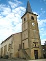
Saint Martin Church

Fixed house


traffic
The Hatrize stop is on the Saint-Hilaire-au-Temple-Hagondange railway line .
Web links
Commons : Hatrize - collection of images, videos and audio files