
Labry
| Labry | ||
|---|---|---|

|
|
|
| region | Grand Est | |
| Department | Meurthe-et-Moselle | |
| Arrondissement | Briey | |
| Canton | Jarny | |
| Community association | Orne Lorraine Confluences | |
| Coordinates | 49 ° 10 ' N , 5 ° 53' E | |
| height | 186-228 m | |
| surface | 5.95 km 2 | |
| Residents | 1,566 (January 1, 2017) | |
| Population density | 263 inhabitants / km 2 | |
| Post Code | 54800 | |
| INSEE code | 54286 | |
| Website | http://www.mairie-labry.fr/ | |

Labry is a French commune with 1,566 inhabitants (as of January 1, 2017) in the Meurthe-et-Moselle department in the Grand Est region (until 2015 Lorraine ). It belongs to the arrondissement of Briey and the canton of Jarny (until 2015: canton of Conflans-en-Jarnisy ).
geography
Labry is 28 kilometers west-northwest of Metz . Labry is surrounded by the neighboring communities of Abbéville-lès-Conflans in the north and north-west, Hatrize in the east and north-east, Giraumont in the east, Jarny in the south and Conflans-en-Jarnisy in the west and south-west.
The A4 autoroute runs along the northern edge of the municipality.
Population development
| year | 1962 | 1968 | 1975 | 1982 | 1990 | 1999 | 2006 | 2017 |
| Residents | 1419 | 1456 | 1345 | 1301 | 1486 | 1578 | 1659 | 1566 |
| Sources: Cassini and INSEE | ||||||||
Attractions
- Saint-Gorgon church from 1836/1837
- Saint-Roch chapel, built in the second half of the 19th century
- Castle, called Turm Mahuet ( tour Mahout ), from the 13th century
- Remains of an earlier hill fort (moth)
- 19th century hospice
- Colombier manor
- German-French-Soviet military cemetery with fallen soldiers of the First World War
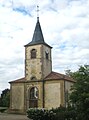
Saint-Gorgon Church

Saint Roch chapel

Castle "Turm Mahuet"
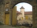
Colombier manor


Web links
Commons : Labry - collection of images, videos and audio files