
Valleroy (Meurthe-et-Moselle)
| Valleroy | ||
|---|---|---|

|
|
|
| region | Grand Est | |
| Department | Meurthe-et-Moselle | |
| Arrondissement | Briey | |
| Canton | Jarny | |
| Community association | Orne Lorraine Confluences | |
| Coordinates | 49 ° 13 ' N , 5 ° 56' E | |
| height | 181-252 m | |
| surface | 12.26 km 2 | |
| Residents | 2,334 (January 1, 2017) | |
| Population density | 190 inhabitants / km 2 | |
| Post Code | 54910 | |
| INSEE code | 54542 | |
| Website | http://valleroy54.fr/ | |

Valleroy is a French commune with 2,334 inhabitants (as of January 1, 2017) in the Meurthe-et-Moselle department in the Grand Est region (before 2016 Lorraine ). It belongs to the Arrondissement of Briey and the Canton of Jarny (until 2015 Homécourt ).
geography
Valleroy is located about 18 kilometers northwest of Metz on the Orne River . Valleroy is surrounded by the neighboring communities of Les Baroches in the north and north-west, Moutiers in the north and north-east, Auboué in the east, Moineville in the south, Hatrize in the south and south-west and Abbéville-lès-Conflans in the west and south-west.
Population development
| year | 1962 | 1968 | 1975 | 1982 | 1990 | 1999 | 2006 | 2017 |
| Residents | 2598 | 2271 | 2185 | 2196 | 2337 | 2296 | 2429 | 2334 |
Attractions
- Saint-Urbain church, originally from the 13th / 14th centuries Century, rebuilt from 1728
- Hizette cross from 1635, monument historique since 1988
- Valleroy Castle, built in 1689
- Valleroy mine, developed from 1907
- soviet military cemetery
- Rectory from the 17th century, reconstructed in 1743
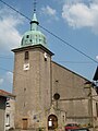
Saint-Urbain church
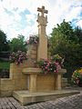
Hizette cross
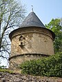
Dovecote at Valleroy Castle


Parish partnership
A partnership has existed with the Italian municipality of Barisciano in the province of L'Aquila (Abruzzo) since 1982 .
traffic
The Valleroy-Moineville stop is on the Saint-Hilaire-au-Temple-Hagondange railway line and used to be the starting point for the Valleroy-Moineville – Villerupt-Micheville railway .