Fillières
| Fillières | ||
|---|---|---|
|
|
||
| region | Grand Est | |
| Department | Meurthe-et-Moselle | |
| Arrondissement | Briey | |
| Canton | Villerupt | |
| Community association | Longwy | |
| Coordinates | 49 ° 24 ' N , 5 ° 51' E | |
| height | 265-410 m | |
| surface | 14.21 km 2 | |
| Residents | 510 (January 1, 2017) | |
| Population density | 36 inhabitants / km 2 | |
| Post Code | 54560 | |
| INSEE code | 54194 | |
| Website | http://www.fillieres.fr/ | |
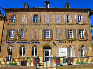
 Fillières Town Hall |
||
Fillières is a French commune with 510 inhabitants (as of January 1, 2017) in the Meurthe-et-Moselle department in the Grand Est region . It belongs to the Arrondissement of Briey and is part of the canton of Villerupt .
geography
The municipality is located about 25 kilometers west of Thionville and 15 kilometers southeast of Longwy in the Bassin de Longwy of the same name near the border area with Belgium and Luxembourg . The Crusnes River runs along the southern municipal boundary . The neighboring communities are:
- Bréhain-la-Ville in the northeast,
- Errouville in the east,
- Serrouville in the southeast,
- Joppécourt in the southwest,
- Ville-au-Montois to the west and
- Morfontaine in the northwest.
The municipal area is accessed by the departmental roads D16 and D27. Higher-ranking traffic connections run in the neighboring communities to the east (e.g. A30 motorway ).
Population development
| year | 1962 | 1968 | 1975 | 1982 | 1990 | 1999 | 2008 | 2013 |
| Residents | 516 | 452 | 427 | 395 | 384 | 396 | 468 | 507 |
Attractions
- Saint-Maurice Church
- Chani chapel
- Military cemetery and memorial for the fallen of the First World War (Nécropole nationale)
Web links
Commons : Fillières - Collection of images, videos and audio files
