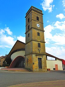
Lexy
| Lexy | ||
|---|---|---|

|
|
|
| region | Grand Est | |
| Department | Meurthe-et-Moselle | |
| Arrondissement | Briey | |
| Canton | Longwy | |
| Community association | Longwy | |
| Coordinates | 49 ° 30 ' N , 5 ° 44' E | |
| height | 239-380 m | |
| surface | 5.99 km 2 | |
| Residents | 3,725 (January 1, 2017) | |
| Population density | 622 inhabitants / km 2 | |
| Post Code | 54720 | |
| INSEE code | 54314 | |
| Website | http://lexy.fr/ | |
Lexy is a French commune with 3725 inhabitants (as of January 1, 2017) in the Meurthe-et-Moselle department in the Grand Est region (until 2015 Lorraine ). It belongs to the arrondissement of Briey and the canton of Longwy (until 2015: canton of Mont-Saint-Martin ). The inhabitants are called Léxéens .
geography
Lexy is on the Chiers River . Lexy is surrounded by the neighboring municipalities of Cosnes-et-Romain in the north, Longwy in the northeast, Réhon in the east and southeast, Cutry in the south, Cons-la-Grandville in the southwest and Villers-la-Chèvre in the west.
history
The place was first mentioned in the 13th century.
Population development
| year | 1962 | 1968 | 1975 | 1982 | 1990 | 1999 | 2006 | 2011 | 2014 |
| Residents | 2.143 | 2,627 | 3,013 | 3,377 | 2,962 | 2,993 | 2,874 | 3.176 | 3,474 |
Attractions
- Nativité-de-la-Vierge church
- World War I ossuary; French military cemetery from the First World War
Culture
A comic festival has been held in the village since 2005
Web links
Commons : Lexy - collection of pictures, videos and audio files

