
Baslieux
| Baslieux | ||
|---|---|---|

|
|
|
| region | Grand Est | |
| Department | Meurthe-et-Moselle | |
| Arrondissement | Briey | |
| Canton | Mont-Saint-Martin | |
| Community association | Terre Lorraine du Longuyonnais | |
| Coordinates | 49 ° 26 ' N , 5 ° 46' E | |
| height | 244-392 m | |
| surface | 10.17 km 2 | |
| Residents | 581 (January 1, 2017) | |
| Population density | 57 inhabitants / km 2 | |
| Post Code | 54620 | |
| INSEE code | 54049 | |
| Website | http://www.baslieux.fr/ | |
_mairie.JPG) Baslieux Town Hall |
||

Baslieux is a French commune with 581 inhabitants (as of January 1, 2017) in the Meurthe-et-Moselle department in the Grand Est region (before 2016 Lorraine ). It belongs to the Arrondissement of Briey and is part of the canton of Mont-Saint-Martin (until 2015 Villerupt ).
geography
Baslieux is about thirty kilometers west-northwest of Thionville and 15 kilometers south-southwest of Longwy near the border area with Belgium and Luxembourg . Baslieux is surrounded by the neighboring communities Ugny in the north and northwest, Chenières in the north and northeast, Laix in the east, Ville-au-Montois in the southeast, Bazailles in the south, Pierrepont in the south and southwest and Doncourt-lès-Longuyon in the west.
Population development
| year | 1962 | 1968 | 1975 | 1982 | 1990 | 1999 | 2006 | 2013 |
| Residents | 1,051 | 1,054 | 962 | 780 | 493 | 534 | 564 | 587 |
| Source: Cassini and INSEE | ||||||||
Attractions
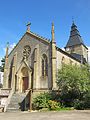
- Saint-Pierre-et-Saint-Paul church, rebuilt in 1560, monument historique
- Notre-Dame-de-Bonté chapel, built in 1664
- Rectory from 1773
- French military cemetery
Saint-Pierre-et-Saint-Paul church

Notre-Dame-de-Bonté chapel

_chapelle_N.D._de_Bont%C3%A9.JPG)