Puxieux
| Puxieux | ||
|---|---|---|

|
|
|
| region | Grand Est | |
| Department | Meurthe-et-Moselle | |
| Arrondissement | Briey | |
| Canton | Jarny | |
| Community association | Mad et Moselle | |
| Coordinates | 49 ° 5 ' N , 5 ° 53' E | |
| height | 223-276 m | |
| surface | 5.67 km 2 | |
| Residents | 250 (January 1, 2017) | |
| Population density | 44 inhabitants / km 2 | |
| Post Code | 54800 | |
| INSEE code | 54441 | |
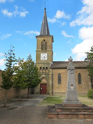
 Sainte-Cécile village church |
||
Puxieux is a French commune with 250 inhabitants (as of January 1, 2017) in the Meurthe-et-Moselle department in the Grand Est region (before 2016 Lorraine ). It belongs to the arrondissement of Briey and the canton of Jarny (until 2015 canton of Chambley-Bussières ).
geography
The municipality is located about 21 kilometers west-southwest of Metz . Neighboring communities are Tronville in the northeast, Chambley-Bussières in the southeast and south, Xonville in the southwest, Sponville in the west and Mars-la-Tour in the northwest and north.
history
Puxieux belonged to the Duchy of Bar , which fell to France in 1766. Until the French Revolution , the community was then in the Grand-gouvernement de Lorraine-et-Barrois . From 1810 to 1833 Puxieux Mars-la-Tour and from 1833 to 1845 Tronville was incorporated. The municipality was in the old Moselle department until 1871, since then it has been part of the Meurthe-et-Moselle department .
Population development
| year | 1793 | 1886 | 1962 | 1968 | 1975 | 1982 | 1990 | 1999 | 2007 | 2015 |
| Residents | 203 | 281 | 159 | 176 | 146 | 120 | 140 | 179 | 243 | 258 |
| Source: Cassini and INSEE | ||||||||||
Attractions
- Houses and farmhouses from the 18th and 19th centuries
- Village church of Sainte-Cécile from the 19th century
- Memorial to the Fallen
- 19th century lavoir (wash house)
