
Mercy-le-Haut
| Mercy-le-Haut | ||
|---|---|---|

|
|
|
| region | Grand Est | |
| Department | Meurthe-et-Moselle | |
| Arrondissement | Briey | |
| Canton | Pays de Briey | |
| Community association | Pays de l'Audunois et du Bassin de Landres | |
| Coordinates | 49 ° 22 ′ N , 5 ° 50 ′ E | |
| height | 298-377 m | |
| surface | 13.35 km 2 | |
| Residents | 273 (January 1, 2017) | |
| Population density | 20 inhabitants / km 2 | |
| Post Code | 54560 | |
| INSEE code | 54363 | |
| Website | mercylehautboudrezy.wordpress.com | |

Mercy-le-Haut is a French commune with 1,278 inhabitants (as of January 1, 2017) in the Meurthe-et-Moselle department in the Grand Est region (until 2015 Lorraine ). The municipality belongs to the Arrondissement of Briey and the canton of Pays de Briey (until 2015: canton of Audun-le-Roman ).
geography
Mercy-le-Haut is about 40 kilometers southwest of Luxembourg . Mercy-le-Haut is surrounded by the neighboring communities of Joppécourt in the north, Serrouville in the northeast, Audun-le-Roman in the east, Malavillers in the east and southeast, Murville in the south, Preutin-Higny in the south and southwest, Xivry-Circourt in the west and Southwest and Mercy-le-Bas in the northwest.
Population development
| year | 1962 | 1968 | 1975 | 1982 | 1990 | 1999 | 2006 | 2013 |
|---|---|---|---|---|---|---|---|---|
| Residents | 315 | 297 | 265 | 271 | 285 | 275 | 248 | 266 |
| Source: Cassini and INSEE | ||||||||
Attractions
- Saint-Salvin Church, built in 1847
- Décollation-de-Saint-Jean-Baptiste church in Boudrezy, built in 1752
- Chapel of Mercy-le-Haut (1866)
- Boudrezy Chapel (1737)
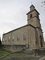
Saint-Salvin church

Church of Décollation-de-Saint-Jean-Baptiste
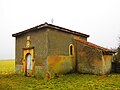
Boudrezy Chapel


Personalities
- Pierre Brully (1515 or 1520–1545), reformer
- Albert Lebrun (1871–1950), French President (1932–1940)