
Cutry (Meurthe-et-Moselle)
| Cutry | ||
|---|---|---|

|
|
|
| region | Grand Est | |
| Department | Meurthe-et-Moselle | |
| Arrondissement | Briey | |
| Canton | Longwy | |
| Community association | Longwy | |
| Coordinates | 49 ° 29 ′ N , 5 ° 45 ′ E | |
| height | 242-393 m | |
| surface | 5.97 km 2 | |
| Residents | 1,033 (January 1, 2017) | |
| Population density | 173 inhabitants / km 2 | |
| Post Code | 54720 | |
| INSEE code | 54151 | |
_mairie.JPG) Town Hall (Mairie) of Cutry |
||

Cutry is a French commune with 1,033 inhabitants (as of January 1, 2017) in the Meurthe-et-Moselle department in the Grand Est region (until 2015 Lorraine ). It belongs to the Arrondissement of Briey and the canton of Longwy (until 2015 Mont-Saint-Martin ). The inhabitants are called Custériens .
geography
The community Cutry is about 42 kilometers west-northwest of Thionville am Chiers , which borders the community in the north. Neighboring communities of Cutry are Lexy in the north, Réhon in the northeast, Chenières in the east and southeast, Ugny in the south and southwest and Cons-la-Grandville in the west.
Population development
| year | 1962 | 1968 | 1975 | 1982 | 1990 | 1999 | 2006 | 2013 |
| Residents | 699 | 872 | 1,096 | 1,048 | 887 | 903 | 918 | 1,016 |
| Source: Cassini and INSEE | ||||||||
Attractions
- Necropolis from the 1st / 2nd centuries. AD century
- Saint-Pirmin Church
- Notre-Dame-de-l'Assomption chapel
- Castle and Palace Museum
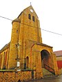
Saint-Pirmin Church
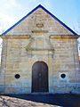
Notre-Dame-de-l'Assomption chapel

Castle Museum


_mus%C3%A9e.JPG)
Web links
Commons : Cutry - collection of images, videos and audio files