
Xonville
| Xonville | ||
|---|---|---|

|
|
|
| region | Grand Est | |
| Department | Meurthe-et-Moselle | |
| Arrondissement | Briey | |
| Canton | Jarny | |
| Community association | Mad et Moselle | |
| Coordinates | 49 ° 3 ' N , 5 ° 51' E | |
| height | 213-251 m | |
| surface | 7.27 km 2 | |
| Residents | 127 (January 1, 2017) | |
| Population density | 17 inhabitants / km 2 | |
| Post Code | 54000 | |
| INSEE code | 54599 | |

Xonville is a French commune with 127 inhabitants (as of January 1, 2017) in the Meurthe-et-Moselle department in the Grand Est region (until 2015 Lorraine ). It belongs to the Arrondissement of Briey and to the community association Mad et Moselle, founded in 2016 .
geography
The municipality is located 14 kilometers south of Jarny and about 25 kilometers southwest of Metz in the Lorraine Regional Nature Park . The mostly flat to gently hilly terrain around Xonville belongs to the eastern Woëvre , a natural landscape between the Meuse and the Moselle . Except for the southern tip ( Bois la Dame ), the area is forestless and covers 7.27 km². The highest point is reached in the northeast of the municipality with 251 m ( Haut de Bijemont ). The small streams in the municipality drain north to the Yron , a tributary of the Orne . In the west, the municipality of Xonville borders on the Meuse department .
Neighboring communities of Xonville are Sponville in the north, Puxieux in the northeast, Chambley-Bussières in the east, Hagéville in the south and Lachaussée in the west.
history
The village belonged to the former province of Trois-Évêchés . In the 16th century, the village of Xonville was under the control of Michel de la Turelle , a captain in the service of Louis XIV. In the 18th century, Nicolas François de Curel , director of the fortresses of Verdun, Longwy, Luxembourg and Malmedy, was the lord of the castle . The name of the village developed as follows:
- • 849 Sionevilla
- • 1346 Xonvilla
- • 1681 Schonville
- • from 1779 Xonville .
Population development
| year | 1962 | 1968 | 1975 | 1982 | 1990 | 1999 | 2004 | 2009 | 2016 |
| Residents | 101 | 111 | 92 | 91 | 105 | 99 | 97 | 133 | 134 |
| Sources: Cassini and INSEE | |||||||||
Xonville is one of the small communities in the Meurthe-et-Moselle department. After the population had decreased in the first half of the 20th century (263 people were still counted in 1876), it stagnated at a low level in the second half of the 20th century, only to slowly increase again at the beginning of the 21st century.
Attractions
- 19th century neo-Gothic church of St. Luke ( Église Saint-Luc )
- Xonville Castle with four square towers from the 17th century
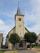
Church of St. Luke

Xonville Castle


Economy and Infrastructure
In the very rural Xoncourt, apart from small craft and service businesses, agriculture dominates (four farms that mainly raise cattle). Meadows and pastures take up over 80% of the community area.
Chambley-Bussières Air Base is located four kilometers southeast of the village of Xonville . The community is located away from the major national traffic routes. Road connections exist to the neighboring communities of Sponville, Chambley-Bussières and Lachaussée. Motorway and train connections in all directions start from the nearby city of Metz .
supporting documents
- ↑ Description on genealogie-lorraine.fr (French)
- ↑ Xonville on cassini.ehess.fr
- ↑ Xonville on insee.fr
- ^ Farmers on annuaire-mairie.fr