Dampvitoux
| Dampvitoux | ||
|---|---|---|

|
|
|
| region | Grand Est | |
| Department | Meurthe-et-Moselle | |
| Arrondissement | Briey | |
| Canton | Jarny | |
| Community association | Mad et Moselle | |
| Coordinates | 49 ° 1 ' N , 5 ° 51' E | |
| height | 209-253 m | |
| surface | 9.19 km 2 | |
| Residents | 58 (January 1, 2017) | |
| Population density | 6 inhabitants / km 2 | |
| Post Code | 54470 | |
| INSEE code | 54153 | |
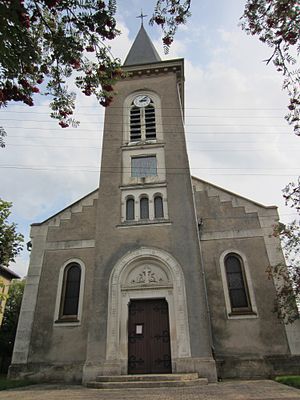
 Saint-Pierre village church |
||
Dampvitoux is a French commune with 58 inhabitants (as of January 1, 2017) in the Meurthe-et-Moselle department in the Grand Est region (before 2016 Lorraine ). It belongs to the arrondissement of Briey and the canton of Jarny (until 2015 canton of Chambley-Bussières ).
geography
The municipality is located about 27 kilometers southwest of Metz on the border with the Meuse department . Neighboring communities are Hagéville in the north and north-east, Dommartin-la-Chaussée in the east and south-east, Charey and Xammes in the south, Vigneulles-lès-Hattonchâtel in the south-west and Lachaussée (in the Meuse department) in the west and north-west. The municipality is located within the Lorraine Regional Nature Park .
history
Dampvitoux historically belonged to the province of Trois-Évêchés (Three Dioceses), which in fact fell to France in 1552. From 1793 to 1801, the municipality was assigned to the arrondissement and district of Metz and incorporated into the canton of Mars-la-Tour. Since 1801 it was assigned to the canton of Gorze (which later became the canton of Chambley). In 1809 the previous Hagéville (1806: 188 inhabitants), Champs (1806: 87 inhabitants) and Dampvitoux (1806: 174 inhabitants) united to form the new municipality of Hagéville. In 1833 Dampvitoux left again. Until 1871, the municipality was in the old Moselle department. Since then it has been part of the Meurthe-et-Moselle department . Since 1871 it has belonged to the Arrondissement of Briey. During the First World War, Dampvitoux was largely destroyed.
Population development
| year | 1793 | 1861 | 1962 | 1968 | 1975 | 1982 | 1990 | 1999 | 2007 | 2015 |
| Residents | 105 | 321 | 85 | 63 | 53 | 47 | 54 | 73 | 70 | 60 |
| Source: Cassini and INSEE | ||||||||||
Attractions
- Saint-Pierre village church , rebuilt after the First World War
- Tomb in the village cemetery from the early 19th century
- Memorial to the Fallen
