Xammes
| Xammes | ||
|---|---|---|

|
|
|
| region | Grand Est | |
| Department | Meurthe-et-Moselle | |
| Arrondissement | Toul | |
| Canton | Le North Toulois | |
| Community association | Mad et Moselle | |
| Coordinates | 48 ° 59 ′ N , 5 ° 51 ′ E | |
| height | 208-280 m | |
| surface | 8.16 km 2 | |
| Residents | 153 (January 1, 2017) | |
| Population density | 19 inhabitants / km 2 | |
| Post Code | 54470 | |
| INSEE code | 54594 | |
 Saint-Clément church |
||
Xammes is a French commune with 153 inhabitants (as of January 1, 2017) in the Meurthe-et-Moselle department in the Grand Est region . It belongs to the arrondissement of Toul and to the community association Mad et Moselle founded in 2016 . The residents call themselves Xammois .
geography
The small community is located on a plateau above the left Moselle tributary Rupt de Mad , about 25 kilometers southwest of Metz . In the west, the Meuse department borders on the municipal area, which mainly consists of fields and meadows. Smaller forest areas can be found in the northeast and west ( Bois de Xammes ). The territory of the municipality is part of the Lorraine Regional Nature Park .
Neighboring municipalities of Xammes are Charey in the northeast, Jaulny in the east, Thiaucourt-Regniéville in the south, Beney-en-Woëvre in the southwest and Dampvitoux in the northwest.
Population development
| year | 1962 | 1968 | 1975 | 1982 | 1990 | 1999 | 2007 | 2017 | |
| Residents | 116 | 131 | 102 | 105 | 122 | 121 | 125 | 153 | |
| Sources: Cassini and INSEE | |||||||||
coat of arms
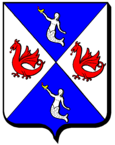
The shape of the bevel is based on the X for Xammes . The silver sirens on a blue background are borrowed from the coat of arms of Mathieu Moulon , Lord of Xammes. The red winged dragons are the attribute of Saint Clement, Bishop of Metz and patron saint of the parish of Xammes.
Attractions
- Church of St. Clemens ( Église Saint-Clément ) from the 12th and 13th centuries in the center of the village, Monument historique
Economy and Infrastructure
Five farms are located in the municipality (cultivation of grain and bush fruits, goat and sheep breeding).
The D 904 trunk road runs from Verdun to Toul four kilometers southwest of Xammes . The LGV Est européenne line from Lorraine to Paris crosses the south of the municipality.
supporting documents
- ↑ Xammes on cassini.ehess.fr
- ↑ Xammes on insee.fr
- ↑ Description of the coat of arms on genealogie-lorraine.fr (French)
- ↑ culture.gouv.fr/public/mistral/merimee
- ↑ Farms on annuaire-mairie.fr (French)
