
Domgermain
| Domgermain | ||
|---|---|---|

|
|
|
| region | Grand Est | |
| Department | Meurthe-et-Moselle | |
| Arrondissement | Toul | |
| Canton | Toul | |
| Community association | Terres Touloises | |
| Coordinates | 48 ° 39 ′ N , 5 ° 50 ′ E | |
| height | 219-414 m | |
| surface | 13.09 km 2 | |
| Residents | 1,185 (January 1, 2017) | |
| Population density | 91 inhabitants / km 2 | |
| Post Code | 54119 | |
| INSEE code | 54162 | |

Domgermain is a French commune with 1,185 inhabitants (as of January 1, 2017) in the Meurthe-et-Moselle department in the Grand Est region (until 2015 Lorraine ). It belongs to the Arrondissement of Toul and the Canton of Toul (until 2015: Canton of Toul-Sud ).
geography
Domgermain is about 20 kilometers west-southwest of Nancy and five kilometers southwest of Toul . Neighboring communities of Domgermain are Choloy-Ménillot in the north and west, Écrouves in the north-east, Toul in the east and north-east, Charmes-la-Côte in the south and Rigny-Saint-Martin in the south-west.
The Route nationale 4 runs through the northeast of the municipality . The station is on the Culmont-Chalindrey-Toul railway line .
The municipality is part of the Côtes de Toul wine-growing region .
Population development
| year | 1962 | 1968 | 1975 | 1982 | 1990 | 1999 | 2006 | 2017 |
| Residents | 794 | 756 | 735 | 912 | 1002 | 1084 | 1234 | 1185 |
| Sources: Cassini and INSEE | ||||||||
Attractions
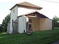
- Saint-Maurice Church
- Saint-Maurice chapel from the 15th century
- Fort von Domgermain, 19th century fortress
- old faience from Bois-le-Comte

Saint-Maurice Church
Saint-Maurice Chapel

Fort from Domgermain


