
Gémonville
| Gémonville | ||
|---|---|---|

|
|
|
| region | Grand Est | |
| Department | Meurthe-et-Moselle | |
| Arrondissement | Toul | |
| Canton | My au Saintois | |
| Community association | Pays de Colombey et du Sud Toulois | |
| Coordinates | 48 ° 25 ' N , 5 ° 53' E | |
| height | 331-428 m | |
| surface | 9.03 km 2 | |
| Residents | 75 (January 1, 2017) | |
| Population density | 8 inhabitants / km 2 | |
| Post Code | 54115 | |
| INSEE code | 54220 | |
 Partial view of the village |
||

Gémonville is a French commune with 75 inhabitants (as of January 1, 2017) in the Meurthe-et-Moselle department in the Grand Est region (until 2015 Lorraine ). It belongs to the arrondissement of Toul and the canton of Meine au Saintois ( canton Colombey-les-Belles until 2015 ).
geography
Gémonville is about 29 kilometers south of Toul, east of the A31 autoroute on the border with the Vosges department . The neighboring municipalities of Gémonville are Favières in the north, Aroffe (in the Vosges department) in the east and south, Aouze (in the Vosges department) in the south, Attignéville (in the Vosges department) in the southwest, Tranqueville-Graux (in the Vosges department) in the west and Harmonville (in the Vosges department) in the north-west. Large parts of the north of the municipality are covered by the Bois de la Grande Voie forest . The Aroffe crosses the village in a north-westerly direction.
history
Excavations with finds from the Bronze Age and from the Gallo-Roman period prove an early settlement. The name of today's municipality was first mentioned in a document in the form of Gemonvilla in 1362 . In the Middle Ages the community belonged to the Duchy of Bar , which later fell to the Duchy of Lorraine . More precisely to the office ( Bailliage ) Vézelise. With this rule Gémonville fell to France in 1766. Until the French Revolution , the community was then in the Grand-gouvernement de Lorraine-et-Barrois . From 1793 to 1801 the municipality was assigned to the district of Vézelise and part of the canton of Favières. Then from 1801 to 2015 part of the canton of Colombey-les-Belles. With the exception of the years 1926 to 1943, when it belonged to the Arrondissement of Nancy, Gémonville has been assigned to the Arrondissement of Toul since 1801. Until 1871, the community was in the old Meurt (h) e. Since then it has been part of the Meurthe-et-Moselle department .
Population development
| year | 1793 | 1800 | 1841 | 1911 | 1921 | 1962 | 1968 | 1975 | 1982 | 1990 | 1999 | 2006 | 2015 |
| Residents | 462 | 368 | 539 | 249 | 187 | 126 | 101 | 102 | 95 | 86 | 91 | 72 | 73 |
| Source: Cassini and INSEE | |||||||||||||
Attractions
- Remains of an oppidum, a necropolis and two barrows from the Bronze Age
- numerous houses from the 18th century
- Church Saint-Privat 19th century
- Village cemetery
- Memorial to the Fallen
- two wayside crosses near the D129 north of the village
- former lavoir (wash house)
- Water tower

Mairie (Town Hall) of Gémonville

Bridge over the Aroffe River
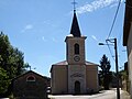
Saint-Privat village church

former mill

former wash house (Lavoir)

Landscape near Gémonville


