Dommartin-lès-Toul
| Dommartin-lès-Toul | ||
|---|---|---|

|
|
|
| region | Grand Est | |
| Department | Meurthe-et-Moselle | |
| Arrondissement | Toul | |
| Canton | Toul | |
| Community association | Terres Touloises | |
| Coordinates | 48 ° 40 ′ N , 5 ° 55 ′ E | |
| height | 201-295 m | |
| surface | 6.87 km 2 | |
| Residents | 1,984 (January 1, 2017) | |
| Population density | 289 inhabitants / km 2 | |
| Post Code | 54200 | |
| INSEE code | 54167 | |
| Website | http://www.dommartin-les-toul.com/ | |
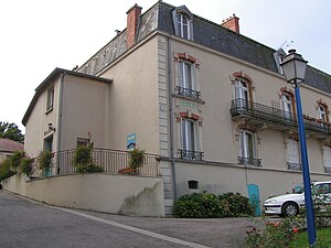
 Town hall of Dommartin-lès-Toul |
||
Dommartin-lès-Toul is a French commune with 1,984 inhabitants (as of January 1, 2017) in the Meurthe-et-Moselle department in the Grand Est region (until 2015 Lorraine ). It belongs to the arrondissement of Toul and the canton of Toul .
geography
Dommartin-lès-Toul lies on the Moselle . The neighboring communities of Dommartin-lès-Martin are Toul in the north and west, Gondreville in the east, Villey-le-Sec in the southeast and Chaudeney-sur-Moselle in the south.
The A31 autoroute runs through the municipality .
history
During the Second World War, the Frontstalag 162 (German prisoner of war camp) was located here.
Population development
| year | 1962 | 1968 | 1975 | 1982 | 1990 | 1999 | 2006 | 2012 | 2017 |
| Residents | 1,081 | 1.004 | 1,218 | 1,714 | 1,639 | 1,644 | 1,971 | 2,001 | 1,984 |
Attractions
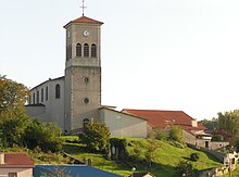
- Saint-Martin church from 1841
- Old castle of the Counts of Fontenoy
- Remains of the Gallo-Roman villa
Personalities
- Benjamin Jeannot (* 1992), football player
Web links
Commons : Dommartin-lès-Toul - Collection of images, videos and audio files

