
Mont-l'Etroit
| Mont-l'Etroit | ||
|---|---|---|

|
|
|
| region | Grand Est | |
| Department | Meurthe-et-Moselle | |
| Arrondissement | Toul | |
| Canton | My au Saintois | |
| Community association | Pays de Colombey et du Sud Toulois | |
| Coordinates | 48 ° 30 ' N , 5 ° 47' E | |
| height | 286-427 m | |
| surface | 6.42 km 2 | |
| Residents | 92 (January 1, 2017) | |
| Population density | 14 inhabitants / km 2 | |
| Post Code | 54170 | |
| INSEE code | 54379 | |
| Website | http://montletroit.fr/ | |
 Mairie (Town Hall) of the parish |
||

Mont-l'Étroit is a French commune with 92 inhabitants (as of January 1, 2017) in the Meurthe-et-Moselle department in the Grand Est region (until 2015 Lorraine ). It belongs to the arrondissement of Toul and the canton of Meine au Saintois ( canton Colombey-les-Belles until 2015 ).
geography
Mont-l'Étroit is located about 21 kilometers southwest of Toul a few kilometers west of the A31 autoroute on the borders with the Meuse and Vosges departments . The neighboring municipalities of Mont-l'Étroit are Saulxures-lès-Vannes in the north and northeast, Punerot (in the Vosges department) in the southeast, Ruppes (in the Vosges department) in the south, Clérey-la-Côte (in the Vosges department) in the southwest as well Sauvigny (in the Meuse department) to the west.
history
The name of today's municipality was (probably) first mentioned in a document in the 10th century in the form of Montenonis . The name is secured as Montes en atroies in 1402. In the Middle Ages, the community belonged to the Trois-Évêchés area . More precisely to the office ( Bailliage ) Toul of the Diocese of Toul. With this rule the community fell to France in 1552. Until the French Revolution , the community was then in the Grand-gouvernement de Lorraine-et-Barrois . From 1793 to 1801 the municipality was assigned to the Toul district and part of the Allamps canton. From 1801 to 2015, the municipality was incorporated into the canton of Colombey-les-Belles. With the exception of the years 1926 to 1943, when it belonged to the Arrondissement of Nancy, Mont-l'Étroit has been assigned to the Arrondissement of Toul since 1801. Until 1871, the community was in the old Meurt (h) e. Since then it has been part of the Meurthe-et-Moselle department . The hurricane Lothar destroyed in 1999, significant parts of the forests of the community.
Population development
| year | 1793 | 1851 | 1962 | 1968 | 1975 | 1982 | 1990 | 1999 | 2006 | 2015 |
| Residents | 201 | 259 | 77 | 78 | 74 | 56 | 57 | 87 | 110 | 92 |
| Source: Cassini and INSEE | ||||||||||
Attractions
- Church Saint-Remy in the 18th century
- Memorial to the Fallen
- Former lavoir (wash house), now a multi-purpose room
- Landmark site des trois bornes at the point where the departments of Meurthe-et-Moselle, Meuse and Vosges meet
- three wayside crosses; the one in the center of the village, the Croix du Vau north-west of the village and the Croix Saint-Rémy on the northern municipal boundary
- few remnants of the Roman road from Lyon to Trier

Memorial to the Fallen
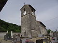
Saint-Rémy village church

Entrance to the village and water tower


