
Villey-le-Sec
| Villey-le-Sec | ||
|---|---|---|

|
|
|
| region | Grand Est | |
| Department | Meurthe-et-Moselle | |
| Arrondissement | Toul | |
| Canton | Toul | |
| Community association | Terres Touloises | |
| Coordinates | 48 ° 40 ′ N , 5 ° 59 ′ E | |
| height | 207-340 m | |
| surface | 6.4 km 2 | |
| Residents | 405 (January 1, 2017) | |
| Population density | 63 inhabitants / km 2 | |
| Post Code | 54840 | |
| INSEE code | 54583 | |
| Website | http://www.villey-le-sec.com/ | |
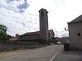
 Town hall and church of Villey-le-Sec |
||

Villey-le-Sec is a French commune with 405 inhabitants (as of January 1, 2017) in the Meurthe-et-Moselle department in Lorraine in the Grand Est region . It belongs to the Arrondissement of Toul and the Canton of Toul (until 2015: Canton of Toul-Sud ). The inhabitants are called Trabecs .
geography
Villey-le-Sec is located about 20 kilometers west-southwest of Nancy and about six kilometers east-southeast of Toul on the Moselle (French: Moselle ). Neighboring municipalities of Villey-le-Sec are Gondreville in the north and east, Sexey-aux-Forges in the east and south-east, Pierre-la-Tiche in the south and south-west, Chaudeney-sur-Moselle in the west and Dommartin-lès-Toul in the north-west.
Population development
| year | 1962 | 1968 | 1975 | 1982 | 1990 | 1999 | 2006 | 2013 |
| Residents | 216 | 162 | 214 | 233 | 239 | 340 | 405 | 413 |
| Source: Cassini and INSEE | ||||||||
Attractions
- Church of the Birth of Our Lady (Nativité-de-la-Vierge), rebuilt in 1955
- Villey-le-Sec fortress
Church of the Birth of Mary

Villey-le-Sec fortress


Web links
Commons : Villey-le-Sec - collection of images, videos and audio files