
Allamps
| Allamps | ||
|---|---|---|

|
|
|
| region | Grand Est | |
| Department | Meurthe-et-Moselle | |
| Arrondissement | Toul | |
| Canton | My au Saintois | |
| Community association | Pays de Colombey et du Sud Toulois | |
| Coordinates | 48 ° 33 ' N , 5 ° 49' E | |
| height | 270-422 m | |
| surface | 7.21 km 2 | |
| Residents | 510 (January 1, 2017) | |
| Population density | 71 inhabitants / km 2 | |
| Post Code | 54112 | |
| INSEE code | 54010 | |
| Website | http://www.allamps.fr / | |
 Town Hall ( Mairie ) of Allamps |
||

Allamps is a French commune with 510 inhabitants (as of January 1, 2017) in the Meurthe-et-Moselle department in the Grand Est region (before 2016 Lorraine ). The municipality is located in the arrondissement of Toul , is part of the Communauté de communes du Pays de Colombey et du Sud Toulois and belongs to the canton of Meine au Saintois ( Colombey-les-Belles until 2015 ). The inhabitants are called allampois .
geography
Allamps is about 20 kilometers south-southwest of Toul am Aroffe . Neighboring communities of Vannes-le-Châtel are Blénod-lès-Toul in the north, Bulligny in the north and north-east, Barisey-la-Côte in the east, Saulxures-lès-Vannes in the south and Vannes-le-Châtel in the west and north-west.
Residents
| 1962 | 1968 | 1975 | 1982 | 1990 | 1999 | 2006 | 2013 | |
|---|---|---|---|---|---|---|---|---|
| 510 | 485 | 434 | 438 | 515 | 511 | 517 | 531 | |
| Source: Cassini and INSEE | ||||||||
Attractions
- Saint-Pierre-et-Saint-Paul church from the 13th century, monument historique
- Notre-Dame-des-Gouttes chapel in Housselmont from the 17th century
- Remains of the castle from around 1600
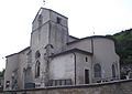
Saint-Pierre-et-Saint-Paul church

Notre-Dame-des-Gouttes chapel

.jpg)