Gondreville (Meurthe-et-Moselle)
| Gondreville | ||
|---|---|---|

|
|
|
| region | Grand Est | |
| Department | Meurthe-et-Moselle | |
| Arrondissement | Toul | |
| Canton | Le North Toulois | |
| Community association | Terres Touloises | |
| Coordinates | 48 ° 42 ' N , 5 ° 58' E | |
| height | 196-330 m | |
| surface | 25.03 km 2 | |
| Residents | 2,801 (January 1, 2017) | |
| Population density | 112 inhabitants / km 2 | |
| Post Code | 54840 | |
| INSEE code | 54232 | |
| Website | http://mairie.gondreville.free.fr/ | |
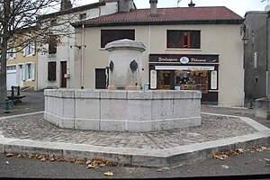
 Place de la Fontaine |
||
Gondreville is a French commune with 2,801 inhabitants (as of January 1, 2017) in the Meurthe-et-Moselle department in the Grand Est region (until 2015 Lorraine ). It belongs to the Arrondissement of Toul and the canton of Le Nord-Toulois (until 2015: Canton of Toul-Nord ).
geography
The municipality is located between Toul and Nancy on the right eastern bank of the Moselle . Neighboring municipalities of Gondreville are
- Fontenoy-sur-Moselle in the northeast,
- Bois-de-Haye with Velaine-en-Haye in the east,
- Marron in the southeast,
- Sexey-aux-Forges and Villey-le-Sec in the south,
- Dommartin-lès-Toul in the southwest,
- Toul in the west,
- Villey-Saint-Etienne in the north-west.
The Grotte du Géant is a natural cave on the right bank of the Moselle in Gondreville.
Population development
| year | 1968 | 1975 | 1982 | 1990 | 1999 | 2006 |
| Residents | 1,274 | 1,476 | 1,592 | 2.145 | 2,215 | 2,845 |
Parish partnership
- Mörlenbach in the Odenwald , Germany
Web links
Commons : Gondreville - collection of images, videos and audio files
