
Bicqueley
| Bicqueley | ||
|---|---|---|

|
|
|
| region | Grand Est | |
| Department | Meurthe-et-Moselle | |
| Arrondissement | Toul | |
| Canton | Toul | |
| Community association | Terres Touloises | |
| Coordinates | 48 ° 38 ' N , 5 ° 55' E | |
| height | 207–338 m | |
| surface | 16.82 km 2 | |
| Residents | 902 (January 1, 2017) | |
| Population density | 54 inhabitants / km 2 | |
| Post Code | 54200 | |
| INSEE code | 54073 | |
| Website | http://www.bicqueley.fr | |

Bicqueley is a French commune with 902 inhabitants (as of January 1, 2017) in the Meurthe-et-Moselle department in the Grand Est region (until 2015 Lorraine ). It belongs to the Arrondissement of Toul and the Canton of Toul (until 2015: Canton of Toul-Sud ). The inhabitants are called bicquicantois .
geography
Bicqueley is about 20 kilometers west-southwest of Nancy and five kilometers south-southeast of Toul . Neighboring communities of Bicqueley are Toul in the north and north-west, Chaudeney-sur-Moselle in the north, Pierre-la-Treich in the north and north-east, Sexey-aux-Forges in the east and north-east, Ochey in the east and south-east, Moutrot in the south and Gye in the West.
Population development
| year | 1962 | 1968 | 1975 | 1982 | 1990 | 1999 | 2006 | 2013 |
| Residents | 523 | 513 | 542 | 681 | 797 | 792 | 883 | 923 |
| Source: Cassini and INSEE | ||||||||
Attractions
- Saint-Martin church from the 18th century
- Notre-Dame chapel from the 13th century
- 18th century castle
- 17th century bridges
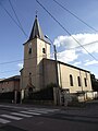
Saint Martin Church

Notre-Dame chapel


Web links
Commons : Bicqueley - collection of images, videos and audio files