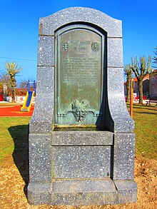
Seicheprey
| Seicheprey | ||
|---|---|---|

|
|
|
| region | Grand Est | |
| Department | Meurthe-et-Moselle | |
| Arrondissement | Toul | |
| Canton | Le North Toulois | |
| Community association | Mad et Moselle | |
| Coordinates | 48 ° 52 ' N , 5 ° 48' E | |
| height | 229-303 m | |
| surface | 8.35 km 2 | |
| Residents | 113 (January 1, 2017) | |
| Population density | 14 inhabitants / km 2 | |
| Post Code | 54470 | |
| INSEE code | 54499 | |
Seicheprey is a French commune with 113 inhabitants (as of January 1, 2017) in the Meurthe-et-Moselle department in the Grand Est region . It belongs to the arrondissement of Toul and the community association Mad et Moselle .
geography
The municipality of Seicheprey is located on a plateau above the left Moselle tributary Rupt de Mad , about 22 kilometers west of Pont-à-Mousson . In the west, the Meuse department borders on the municipal area, which mainly consists of fields. Smaller forest areas can be found in the northeast and east ( Bois de Remíères, Bois du Jury ). The territory of the municipality is part of the Lorraine Regional Nature Park .
Neighboring communities of Seicheprey are Saint-Baussant in the north, Flirey in the east, Bernécourt in the south-east, Mandres-aux-Quatre-Tours and Beaumont in the south, Rambucourt in the south-west, Xivray-et-Marvoisin in the west and Richecourt and Lahayville in the north-west.
history
The first written evidence of the existence of Seicheprey goes back to 1227 when the village was called Sachepree . The place name developed over Sechepree (1283), Seschepreie (1284), Sachepreie (1305) and Sochepré (1326) to the spelling Seicheprey, which has not changed since 1793 until today . Seicheprey has belonged to the Duchy of Bar since the middle of the 14th century . The coat of arms of the community symbolizes on a green background with silver stones the Treaty of Liverdun of June 26, 1632, which was sealed with a handshake , in which the French King Louis XIII. and the Lorraine Duke Charles IV pledged to stand by each other during the Thirty Years' War .
Seicheprey became known nationwide during the First World War , when on April 20, 1918 - before the Battle of St. Mihiel - German units met the American Expeditionary Forces , which had been held back by General Pershing as a precaution until the troop strength was reached . On the morning of June 26th, the 26th US Infantry Division had to repel a German advance from the north. The fighting was fierce and costly for both sides. In the afternoon, the Americans were able to retake Seicheprey in a counter-attack, which was celebrated as a victory in the American press. This victory was bought at a high price, because on the evening of June 26, 1918, at least 80 American soldiers were buried in the 102nd Infantry Brigade alone. In addition there were 424 wounded and 130 captured by the Germans.
The village of Seicheprey was razed to the ground after the battle.
Population development
| year | 1962 | 1968 | 1975 | 1982 | 1990 | 1999 | 2009 | 2017 | |
| Residents | 107 | 85 | 76 | 76 | 72 | 81 | 114 | 113 | |
| Sources: Cassini and INSEE | |||||||||
Attractions
- Church of St. Peter ( Église Saint-Pierre ) from the 13th century in the center of the village, rebuilt in 1925 after being destroyed in the First World War
- American fountain ( La Fontaine américaine ) in memory of American troops
Economy and Infrastructure
Since the end of the Middle Ages, agriculture and animal husbandry have dominated the Seicheprey community. Eleven farms are located in the municipality (grain cultivation, pig farming). Commerce and small businesses are of local importance. Many workers are now commuters who go to work in the cities on the Meuse and Moselle.
The municipality of Seicheprey is located off the nationally important traffic routes. The main road D 958 runs through the southeast of the municipality from Commercy on the Maas to Pont-à-Mousson on the Moselle . The nearest motorway connection to the A 313 is around 23 kilometers away. Further road connections exist to Richecourt and Saint-Baussant . The double-track railway line from Lérouville to Metz , which runs through the west of the municipality, only plays a subordinate role in freight traffic. The nearest train stop is on the Paris – Strasbourg line at Lorraine TGV station, 33 kilometers away .
supporting documents
- ↑ Dictionnaire topographique de la France (French)
- ↑ Description of the coat of arms on genealogie-lorraine.fr (French)
- ↑ American-Expeditionary-Force-Battle-of-Seicheprey (English)
- ↑ James Hallas: Seicheprey . In: Anne Cipriano Venzon (Ed.): The United States in the First World War: an encyclopedia . Routledge, 1999, ISBN 0-8153-3353-6 , pp. 537-540.
- ↑ Seicheprey on cassini.ehess.fr
- ↑ Seicheprey on insee.fr
- ↑ Farms on annuaire-mairie.fr (French)


