
Flirey
| Flirey | ||
|---|---|---|

|
|
|
| region | Grand Est | |
| Department | Meurthe-et-Moselle | |
| Arrondissement | Toul | |
| Canton | Le North Toulois | |
| Community association | Mad et Moselle | |
| Coordinates | 48 ° 53 ' N , 5 ° 51' E | |
| height | 256-332 m | |
| surface | 15.77 km 2 | |
| Residents | 151 (January 1, 2017) | |
| Population density | 10 inhabitants / km 2 | |
| Post Code | 54470 | |
| INSEE code | 54200 | |

Flirey is a French commune with 151 inhabitants (as of January 1, 2017) in the Meurthe-et-Moselle department in the Grand Est region (until 2015 Lorraine ). The municipality belongs to the arrondissement of Toul and the canton of Le Nord-Toulois (until 2015: canton of Thiaucourt-Regniéville ).
geography
Flirey is located about 35 kilometers southeast of Metz in the Lorraine Regional Nature Park . Flirey is surrounded by the neighboring communities Essey-et-Maizerais in the north and north-west, Euvezin in the north, Limey-Remenauville in the east, Noviant-aux-Prés in the south-east, Bernécourt in the south, Seicheprey in the west and south-west and Saint-Baussant in the west.
history
On September 19 and October 11, 1914, the German troops gained territories during the early phase of the First World War. The third French army retreated towards Verdun against the victorious 6th German army.
Population development
| year | 1962 | 1968 | 1975 | 1982 | 1990 | 1999 | 2006 | 2013 |
| Residents | 141 | 149 | 138 | 154 | 144 | 173 | 206 | 161 |
| Source: Cassini and INSEE | ||||||||
Attractions
- Saint-Etienne church, rebuilt in 1918
- Ruins of the former Saint-Étienne church
- National Cemetery
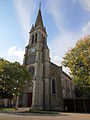
today's Saint-Étienne church

Church ruin

