Arnaville
| Arnaville | ||
|---|---|---|

|
|
|
| region | Grand Est | |
| Department | Meurthe-et-Moselle | |
| Arrondissement | Toul | |
| Canton | Pont-à-Mousson | |
| Community association | Mad et Moselle | |
| Coordinates | ||
| height | 171-354 m | |
| surface | 5.22 km 2 | |
| Residents | 565 (January 1, 2017) | |
| Population density | 108 inhabitants / km 2 | |
| Post Code | 54530 | |
| INSEE code | 54022 | |
| Website | Arnaville | |
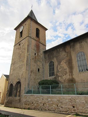
 Saint-Etienne church |
||
Arnaville is a French commune with 565 inhabitants (as of January 1, 2017) in the Meurthe-et-Moselle department in the Grand Est region (until 2015 Lorraine ).
geography
The municipality of Arnaville is located at the confluence of the Rupt de Mad into the Moselle , about halfway between Metz and Pont-à-Mousson . The municipality is part of the Lorraine Regional Nature Park and borders the Moselle department to the north and east .
history
The place was first mentioned in 851 as villa Arnoldi and has belonged to France since 1766. After the Franco-Prussian War , Arnaville was a temporary border town with the German Empire from 1871 to 1918 .
Population development
| year | 1962 | 1968 | 1975 | 1982 | 1990 | 1999 | 2007 | 2017 |
| Residents | 665 | 663 | 640 | 583 | 597 | 609 | 583 | 565 |
Web links
Commons : Arnaville - collection of images, videos and audio files
