
Punk red
| Punk red | ||
|---|---|---|
|
||
| region | Grand Est | |
| Department | Vosges | |
| Arrondissement | Neufchâteau | |
| Canton | Neufchâteau | |
| Community association | Ouest Vosgien | |
| Coordinates | 48 ° 29 ′ N , 5 ° 49 ′ E | |
| height | 283-361 m | |
| surface | 13.77 km 2 | |
| Residents | 157 (January 1, 2017) | |
| Population density | 11 inhabitants / km 2 | |
| Post Code | 88630 | |
| INSEE code | 88363 | |
 Mairie Punerot |
||

Punerot is a French commune with 157 inhabitants (as of January 1, 2017) in the Vosges department in the Grand Est region . It is part of the Neufchâteau arrondissement and the Ouest Vosgien community association founded in 2017 .
geography
Punerot is located about 25 kilometers south of Toul on the border with the Meurthe-et-Moselle department . Punerot is surrounded by the neighboring communities of Saulxures-lès-Vannes in the north, Autreville in the east, Harmonville and Tranqueville-Graux in the southeast, Martigny-les-Gerbonvaux in the south, Ruppes in the west and Mont-l'Étroit in the northwest.
The Culmont-Chalindrey-Toul railway line and the Via Agrippa Roman road from Lyon to Trier run through the municipality .
history
Ceramic and stone finds suggest a settlement during Roman times. Possibly there were thermal baths and baths on Via Agrippa in Punerot.
When the communes and cantons were founded in 1793, the commune was initially called Prunerot (until 1801).
Population development
| year | 1962 | 1968 | 1975 | 1982 | 1990 | 1999 | 2008 | 2017 | |
| Residents | 214 | 189 | 163 | 136 | 112 | 136 | 178 | 157 | |
| Sources: Cassini and INSEE | |||||||||
Attractions
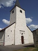
- Saint-Élophe church
- Field cross from 1751 ( La croix Marchal )
- Saint-Élophe church

North side
East Side


Economy and Infrastructure

There are eight farms in the municipality (dairy farming, cattle breeding).
The D 19 trunk road from Autreville to Greux runs through Punerot . Another road connection is to Mont-l'Étroit . The next connection to the A 31 autoroute is ten kilometers northeast of Punerot.
supporting documents
- ↑ Punerot at the presentation of the community association ( Memento of the original from February 19, 2016 in the Internet Archive ) Info: The archive link was inserted automatically and has not yet been checked. Please check the original and archive link according to the instructions and then remove this notice. (French)
- ↑ toponym on cassini.ehess.fr
- ↑ Punerot on cassini.ehess.fr
- ↑ Punerot on insee.fr
- ↑ Flurkreuz Punerot (French)
- ↑ Farms on annuaire-mairie.fr (French)