
They-sous-Montfort
| They-sous-Montfort | ||
|---|---|---|

|
|
|
| region | Grand Est | |
| Department | Vosges | |
| Arrondissement | Neufchâteau | |
| Canton | Vittel | |
| Community association | Terre d'Eau | |
| Coordinates | 48 ° 14 ' N , 5 ° 59' E | |
| height | 330-470 m | |
| surface | 10.21 km 2 | |
| Residents | 127 (January 1, 2017) | |
| Population density | 12 inhabitants / km 2 | |
| Post Code | 88800 | |
| INSEE code | 88466 | |
 Mairie They-sous-Montfort |
||

They-sous-Montfort is a French commune with 127 inhabitants (as of January 1, 2017) in the Vosges department in the Grand Est region (until 2015 Lorraine ). The municipality belongs to the Arrondissement Neufchâteau and the municipality association Terre d'Eau .
The community consists of two parts:
- La Petite They with the town hall, and the school
- La Grande They with the church and a military cemetery
The suffix “-sous-Montfort” ( -under [the] Montfort ) indicates an early connection to the medieval hilltop castle Montfort on the nearby 457 m high Mont Saint-Jean .
geography
The municipality of They-sous-Montfort is located seven kilometers north of the mineral water town of Vittel in hilly and wooded terrain. They-sous-Montfort is surrounded by the neighboring communities of Domjulien in the north, La Neuveville-sous-Montfort in the east, Haréville in the south-east, Vittel in the south and south-west and Saint-Remimont and Parey-sous-Montfort in the north-west.
Population development
| year | 1962 | 1968 | 1975 | 1982 | 1990 | 1999 | 2006 | 2016 | |
| Residents | 239 | 214 | 212 | 188 | 178 | 177 | 163 | 127 | |
| Sources: Cassini and INSEE | |||||||||
Attractions
- Saint-Symphorien Church
- Fallen memorial
- Military cemetery
- Fountain
- Saint-Symphorien Church
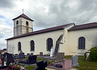
Southeast side
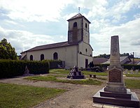
Northwest side and monument to the fallen


Economy and Infrastructure
They-sous-Montfort has a rural character. There are five farms in the municipality (dairy farming, horse breeding).
In Bulgnéville , 16 kilometers away, there is a connection to the A31 autoroute . The nearest train station is in the nearby town of Vittel - on the Merrey – Hymont-Mattaincourt railway line .
supporting documents
- ↑ They-sous-Montfort on cassini.ehess.fr
- ↑ They-sous-Montfort on insee.fr
- ↑ Farms on annuaire-mairie.fr (French)