
Martinvelle
| Martinvelle | ||
|---|---|---|

|
|
|
| region | Grand Est | |
| Department | Vosges | |
| Arrondissement | Neufchâteau | |
| Canton | Darney | |
| Community association | Vosges Côté Sud Ouest | |
| Coordinates | 47 ° 59 ′ N , 6 ° 0 ′ E | |
| height | 249-370 m | |
| surface | 24.73 km 2 | |
| Residents | 122 (January 1, 2017) | |
| Population density | 5 inhabitants / km 2 | |
| Post Code | 88410 | |
| INSEE code | 88291 | |
 Mairie Martinvelle |
||

Martinvelle is a French commune with 122 inhabitants (as of January 1, 2017) and an area of 24.73 square kilometers in the Vosges department in the Grand Est region (until 2015 Lorraine ). Martinvelle is part of the Neufchâteau arrondissement and the Darney canton . Until March 29, 2015, the municipality was in the dissolved canton of Monthureux-sur-Saône .
geography
The municipality of Martinvelle is located on the edge of the Monts Faucilles in the Côney catchment area , about 45 kilometers southwest of Épinal . Martinvelle is surrounded by the neighboring communities Claudon in the north, Passavant-la-Rochère in the east, Vougécourt in the south, Ameuvelle in the south-west, Regnévelle in the west and Monthureux-sur-Saône in the north-west. Martinvelle borders the Haute-Saône department to the east and south . Martinvelle lies at an altitude of 336 meters.
Population development
| year | 1962 | 1968 | 1975 | 1982 | 1990 | 1999 | 2008 | 2014 |
| Residents | 228 | 209 | 196 | 176 | 168 | 135 | 128 | 121 |
Attractions
- Saint-Pierre-aux-Liens church
- Martinvelle Castle from the 17th century
- Fountain
- Lavoir

Saint-Pierre-aux-Liens church
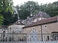
Martinvelle Castle
.JPG)
.JPG)