Passavant-la-Rochère
| Passavant-la-Rochère | ||
|---|---|---|

|
|
|
| region | Bourgogne-Franche-Comté | |
| Department | Haute-Saône | |
| Arrondissement | Lure | |
| Canton | Jussey | |
| Community association | Haute Comté | |
| Coordinates | 47 ° 58 ' N , 6 ° 2' E | |
| height | 227-452 m | |
| surface | 29.89 km 2 | |
| Residents | 603 (January 1, 2017) | |
| Population density | 20 inhabitants / km 2 | |
| Post Code | 70210 | |
| INSEE code | 70404 | |
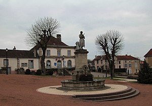
 Joan of Arc square with the town hall |
||
Passavant-la-Rochère is a municipality in the French department of Haute-Saône in the region Bourgogne Franche-Comté .
geography
Passavant-la-Rochère is located at an altitude of 260 m above sea level, 19 kilometers northeast of Jussey and about 40 kilometers north-northwest of the city of Vesoul (as the crow flies). The village extends in the extreme north of the department, slightly elevated above the confluence of the Morte-Eau and Ruisseau de la Noue le Châtelain , on the southwest edge of the heights of Mont Paron .
The area of the 29.89 km² municipal area covers a section in the gently undulating landscape east of the upper Saône valley . From northeast to southwest, the area is crossed by the Morte-Eau valley, which provides drainage over the Côney to the Saône. To the north of Passavant it is dammed up to form the Étang Neuf . Its valley floor is no more than one kilometer wide. From the north and northwest, the Morte-Eau receives inflows from the Ruisseau du Mesnil , Ruisseau de la Noue le Châtelain and Ruisseau du Mirnaut , whose valleys are deepened into the plateau.
The valley system of the Morte-Eau is flanked by a plateau, which is on average 270 m and is mainly used for agriculture. In the south, the municipal area extends into the Côney floodplain, to which the waterway of the Canal de l'Est runs parallel. In the north, a 50 m high step leads to the almost continuously wooded plateau of the Bois de Passavant (330 m). The eastern demarcation is made by the broad, wooded ( Forêt Domaniale de Selles et Passavant ) ridge of Mont Paron , on which the highest elevation of Passavant-la-Rochère is reached at 452 m. From a geological and tectonic point of view, the terrain consists mainly of red sandstone from the Lower Triassic . In some places, shell limestone from the Middle Triassic and sandy-marl and calcareous sediments are exposed that were deposited during the Lias ( Lower Jurassic ).
The municipality consists of the following districts:
- Passavant (260 m) at the confluence of the Morte-Eau and Ruisseau de la Noue le Châtelain
- La Côte (270 m) on the plateau east of the Morte-Eau valley
- La Rochère (280 m) in a cleared island in the Morte-Eau valley basin between Bois de Passavant in the north and Mont Paron in the east
Neighboring municipalities of Passavant-la-Rochère are Claudon and Hennezel in the north, Ambiévillers , Pont-du-Bois and Selles in the east, La Basse-Vaivre , Demangevelle and Vougécourt in the south and Martinvelle in the west.
history
A Roman traffic route led through the area, which indicates a very early settlement. Passavant was first mentioned in a document in 1179. The village was on the border of the Free County of Burgundy, the Duchy of Lorraine and Champagne. Passavant developed into the center of a rulership in the Middle Ages and was a fortified town. The area became famous around 1475 when one of the first glassworks in France was founded. During the Thirty Years' War the place was visited in 1636 by troops of Duke Bernhard von Sachsen-Weimar , with numerous residents being killed.
The area consisted of four municipalities: Passavant, La Rochère and La Côte-des-Vosges (or Côte-Française) in Champagne and La Côte de Passavant (or Côte Lorraine) in Lorraine. Only with the fall of Lorraine to France (1766) were all municipalities united under the French crown. The whole area was - to the displeasure of the majority of non-Lorraine residents - added to the province of Lorraine and in 1790 became part of the Vosges department and since then has formed the municipality of Passavant-la-Rochère. By decree of February 4, 1791, the municipality was assigned to the Haute-Saône department. With the inauguration of the railway line from Jussey to Épinal in 1886, Passavant was connected to the French railway network. Passenger traffic was discontinued in 1944, freight traffic from 1951.
Attractions
The three-aisled church of Passavant was rebuilt in 1843 on the site of a former chapel in the classical style. The furnishings include the altars from the 18th century and various statues and statuettes. The Saint-Antoine chapel east of the valley originally dates from the 13th century (choir) and was renovated in the 16th century; Altar and statues were made in the 17th century.
The round donjon (keep) from the 13th century, which is classified as a monument historique, has been preserved from the former mansion . Other sights include the railway viaduct that spans the Morte-Eau valley. Passavant owns a museum with a collection of modern art. The crystal glass factory is located in La Rochère and is visited by more than 120,000 people every year.
Lavoir in Passavant
population
| Population development | |
|---|---|
| year | Residents |
| 1962 | 1220 |
| 1968 | 1210 |
| 1975 | 1182 |
| 1982 | 1095 |
| 1990 | 874 |
| 1999 | 803 |
| 2006 | 725 |
| 2017 | 603 |
With 603 inhabitants (January 1, 2017), Passavant-la-Rochère is one of the medium-sized communes in the Haute-Saône department. Passavant-la-Rochère reached its highest level of population in 1886 at the time of the greatest boom of the crystal glass factory, when 1862 people were counted. There has been a steady decline in population throughout the 20th century.
Economy and Infrastructure
Passavant-la-Rochère was shaped early on by the glassworks and metal processing industry. Today, the Verrerie La Rochère crystal and glass factory is the region's most important employer. It was founded in 1475 by a noble family and in the 19th century it was run by François-Xavier Fouillot, who bought the company. It is still owned by his descendants today. Production has been partially mechanized since the 1970s. There are also numerous small business enterprises, especially in the precision engineering, metal and wood processing, construction and car garages sectors. As a regional small center, Passavant-la-Rochère has various service companies and retail outlets for daily needs.
The village is located off the major thoroughfares on a departmental road that leads from Jussey to Darney . Further road connections exist with Martinvelle, Selles and La Basse-Vaivre.
Web links
Individual evidence
- ↑ a b Philippe Gloaguen, et al .: Le Routard - Le guide de la visite d'entreprise . No. 79/0425/0 . Hachette Livre, Vanves 2016, ISBN 978-2-01-323703-1 , pp. 62 .


