
Mailleroncourt-Charette
| Mailleroncourt-Charette | ||
|---|---|---|
|
||
| region | Bourgogne-Franche-Comté | |
| Department | Haute-Saône | |
| Arrondissement | Lure | |
| Canton | Saint-Loup-sur-Semouse | |
| Community association | Triangle Vert | |
| Coordinates | 47 ° 44 ' N , 6 ° 16' E | |
| height | 241-360 m | |
| surface | 10.60 km 2 | |
| Residents | 279 (January 1, 2017) | |
| Population density | 26 inhabitants / km 2 | |
| Post Code | 70240 | |
| INSEE code | 70322 | |
 Mairie Mailleroncourt-Charette |
||

Mailleroncourt-Charette is a commune in the French department of Haute-Saône in the region Bourgogne Franche-Comté .
geography
Mailleroncourt-Charette is located at an altitude of 250 m above sea level, four kilometers north-northwest of Saulx and about 14 kilometers north-northeast of the city of Vesoul (as the crow flies). The village extends in the central part of the department, north of the Saulx basin, at the confluence of the Ruisseau de Meurcourt with the Durgeon , south of the heights of Mont Vaulot .
The area of the 10.60 km² large municipal area includes a section in the area of the Saulx basin. From east to west the area is crossed by the valley of the Durgeon. The river valley is first cut into the surrounding plateaus before it widens at Mailleroncourt-Charette. Here the alluvial low lies on average at 245 m and has a maximum width of one kilometer. From the north, the Durgeon takes up three side streams in the municipal area, the valleys of which are also sunk deep into the area: Ruisseau de la Cude , Ruisseau d'Origer and Ruisseau de Meurcourt . They are dammed up to ponds in several places.
To the south-east of the village is the plateau of Les Raichaines with the Point du Jour (312 m). Agricultural use prevails here. To the north, the municipality extends to the densely forested heights of Bois Narbot , Bois Junot and Bois des Landres . At 360 m, the Bois Narbot is the highest point in Mailleroncourt-Charette. From a geological and tectonic point of view, the terrain consists of alternating layers of sandy-marl and calcareous sediments that were deposited during the Lias ( Lower Jurassic ). Red sandstone and shell limestone from the Triassic period also come to light in some places .
In addition to the actual village, Mailleroncourt-Charette includes the following hamlet settlements:
- La Goutte (280 m) on the eastern slope of the Durgeon valley
- Les Landres (319 m) at the height north of the Durgeon Valley
Neighboring municipalities of Mailleroncourt-Charette are Meurcourt , Villers-lès-Luxeuil and Visoncourt in the north, Servigney in the east, Saulx in the south and La Villeneuve-Bellenoye-et-la-Maize in the west.
history
The Roman road from Besançon to Luxeuil ran through the municipality . Mailleroncourt is first mentioned in a document in 1292. In the Middle Ages, the village belonged to the Free County of Burgundy and in it to the area of the Bailliage d'Amont . The local rule was held by the aristocratic Charette family, which went out at the beginning of the 16th century. To avoid confusion with the municipality of Mailleroncourt-Saint-Pancras , the surname was added to the place name. Together with Franche-Comté , Mailleroncourt-Charette finally came to France with the Peace of Nijmegen in 1678. Today Mailleroncourt-Charette is a member of the community association Communauté de communes du Pays de Saulx, which comprises 17 villages .
Attractions
The village church of Mailleroncourt-Charette was rebuilt in 1909 and houses a painted Madonna statue from the 15th century and other statues from the 17th century. In the valley of the Ruisseau d'Origer is the Saint-Léger chapel, which originally dates from the 7th century, but was rebuilt in the 19th century. Other sights include a wayside cross from the 17th century, the manor house, which was restored in the 18th century, to the west of the village, and a fountain with a pavilion (19th century).

Saint-Léger church
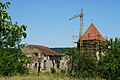
Ruins of the castle

Fountain

Fountain

War memorial

Saint-Léger chapel

Interior of the chapel


population
| Population development | |
|---|---|
| year | Residents |
| 1962 | 323 |
| 1968 | 309 |
| 1975 | 302 |
| 1982 | 321 |
| 1990 | 272 |
| 1999 | 277 |
| 2006 | 298 |
With 279 inhabitants (January 1, 2017) Mailleroncourt-Charette is one of the small communities in the Haute-Saône department. After the population had decreased significantly in the first half of the 20th century (660 people were still counted in 1881), only relatively small fluctuations have been recorded since the early 1970s.
Economy and Infrastructure
Until well into the 20th century, Mailleroncourt-Charette was predominantly a village characterized by agriculture (arable farming, fruit growing and cattle breeding) and forestry. The water power of the streams used to be used to operate several mills. Today there are some local small businesses. In the last few decades the village has transformed into a residential community. Many employed people are therefore commuters who work in the larger towns in the area and in the agglomeration of Vesoul.
The village is located off the major thoroughfares on a departmental road that leads from Saulx to Conflans-sur-Lanterne . Further road connections exist with La Villeneuve , Vilory , Villers-lès-Luxeuil and Servigney .