Mélecey
| Mélecey | ||
|---|---|---|
|
|
||
| region | Bourgogne-Franche-Comté | |
| Department | Haute-Saône | |
| Arrondissement | Lure | |
| Canton | Villersexel | |
| Community association | Pays de Villersexel | |
| Coordinates | 47 ° 31 ' N , 6 ° 29' E | |
| height | 283-375 m | |
| surface | 3.35 km 2 | |
| Residents | 144 (January 1, 2017) | |
| Population density | 43 inhabitants / km 2 | |
| Post Code | 70110 | |
| INSEE code | 70336 | |
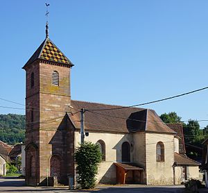
 Saint-Etienne church |
||
Mélecey even Melecey written is a municipality in the French department of Haute-Saône in the region Bourgogne Franche-Comté .
geography
Mélecey is located at an altitude of 300 m above sea level, six kilometers southeast of Villersexel and about 27 kilometers east-southeast of the city of Vesoul (as the crow flies). The village extends in the basin of the Grand Ru on the northwestern edge of the hilly landscape that extends between the river valleys of Ognon and Doubs , at the northwest foot of the Motte de Grammont .
The area of the 3.35 km² municipal area covers a section of the hilly landscape southeast of the Ognon valley. The central part of the area is crossed from south to north by the valley of the Grand Ru , which emerges north of the village into the plain of Villersexel. The stream provides drainage to the Scey . The plain is mainly covered by forest ( Bois de Chenot ). In the south, the landscape is more in relief and extends to the surrounding heights and the western slope of the Motte de Grammont. Agricultural use predominates here. At 375 m, the highest point in Mélecey is reached on the hill west of the village. While the northern part of the municipality is mainly composed of shell limestone , the sandy-marly layers of the Lias emerge in the southern part .
Neighboring municipalities of Mélecey are Villers-la-Ville , Villargent and Georfans in the north, Grammont in the east, Fallon in the south and Les Magny in the west.
history
In the Bois de Chenot tracks were discovered a Roman traffic route. In the Middle Ages, Mélecey belonged to the Marast priory. Together with Franche-Comté , the village finally came to France with the Peace of Nijmegen in 1678. In the 19th century, salt deposits were mined here using coal mines from coal mining in the Vosges and Jura Mountains . Since 2000 Mélecey has been a member of the community association Communauté de communes du Pays de Villersexel, which comprises 33 localities .
- Saltworks
Attractions
The village church of Saint-Étienne in Mélecey dates from the 17th century and is furnished with rich furnishings.
In the village square there is a lavoir (well and former wash house), which was renovated in 1994.
The cemetery, which is just outside the village, shows numerous forged crosses that come from the foundry of neighboring Fallon.
population
| Population development | |
|---|---|
| year | Residents |
| 1962 | 186 |
| 1968 | 165 |
| 1975 | 188 |
| 1982 | 153 |
| 1990 | 189 |
| 1999 | 199 |
| 2017 | 144 |
With 144 inhabitants (January 1, 2017), Mélecey is one of the small communities in the Haute-Saône department. After the population had decreased significantly in the first half of the 20th century (316 people were still counted in 1886), only relatively small fluctuations have been recorded since the early 1960s.
Economy and Infrastructure
Until well into the 20th century, Mélecey was primarily a village characterized by agriculture (arable farming, fruit growing and cattle breeding) and forestry. In addition, there are now some local small businesses. In the meantime, the village has also turned into a residential community. Many workers are therefore commuters who work in the larger towns in the area.
The village is located off the major thoroughfares on a departmental road that leads from Villargent to Fallon. Further road connections exist with Grammont and Georfans.


