
Dambenoît-lès-Colombe
| Dambenoît-lès-Colombe | ||
|---|---|---|

|
|
|
| region | Bourgogne-Franche-Comté | |
| Department | Haute-Saône | |
| Arrondissement | Lure | |
| Canton | Lure-1 | |
| Community association | Triangle Vert | |
| Coordinates | 47 ° 43 ' N , 6 ° 23' E | |
| height | 303-448 m | |
| surface | 8.69 km 2 | |
| Residents | 277 (January 1, 2017) | |
| Population density | 32 inhabitants / km 2 | |
| Post Code | 70200 | |
| INSEE code | 70195 | |
| Website | http://www.dambenoit.com/ | |
 Mairie Dambenoît-lès-Colombe |
||

Dambenoît-lès-Colombe is a commune in the French department of Haute-Saône in the region Bourgogne Franche-Comté .
geography

Dambenoît-lès-Colombe is located at an altitude of 319 m above sea level, ten kilometers west-northwest of Lure and about 21 kilometers northeast of the city of Vesoul (as the crow flies). The village extends in the central part of the department, on the western edge of the plain of Lure, at the eastern foot of the heights of Mont d'Ahie .
The area of the 8.69 km² municipal area includes a section of the plain of Lure. The eastern part of the municipality is occupied by this alluvial plain , which averages 320 m. Agricultural use prevails here. The area is drained to the east by the Bauvier .
South and west of Dambenoît, the terrain rises to the mostly wooded heights of Châtillon (391 m) and Mont Chavrot (421 m). They form the watershed between the Ognon and Saône catchment areas . Further to the west, the valley basin of the Colombine connects , which belongs to the catchment area of this Durgeon . The western boundary is the long, north-south running ridge of the Grand Bois de Genevrey , the northern end of which is the Mont d'Ahie . At 448 m, the highest peak of Dambenoît-lès-Colombe is reached here. From a geological and tectonic point of view, the western section of the municipality, which is more in relief, is made up of alternating layers of sandy, marly and calcareous sediments that were deposited during the Lias ( Lower Jurassic ). Shell limestone from the Middle Triassic also appears in various places .
The municipality consists of the following districts:
- Dambenoît (319 m) on the western edge of the Lure plain
- Colombe-lès-Bithaine (318 m) in the basin of the Colombine east of the Grand Bois de Genevrey
Neighboring municipalities of Dambenoît-lès-Colombe are Ailloncourt and Citers in the north, Quers in the east, Adelans-et-le-Val-de-Bithaine in the south and Genevrey in the west.
history
Remains of a burial ground from the Merovingian period indicate an early settlement of the area. Dambenoît is first mentioned in a document in 1230, but the parish that was dependent on the Calmoutier monastery is much older. In the Middle Ages Dambenoît belonged to the Free County of Burgundy and in it to the area of Bailliage d'Amont . Local rule was held by the Lords of Faucogney. Together with Franche-Comté , the village finally came to France with the Peace of Nijmegen in 1678. The area changed in 1972 when the previously independent municipalities of Dambenoît and Colombe-lès-Bithaine (1968: 19 inhabitants) were merged. Today Dambenoît-lès-Colombe is a member of the Triangle Vert community association .
Attractions
The Saint-Bénigne church was rebuilt in 1785, the current chancel dates from the 19th century. The remarkable furnishings include the pulpit in neo-Gothic style, a wooden crucifix from the 18th century and two frescoes (18th century and around 1900).
Other sights include the fountain (1889) with a large water basin made of red sandstone and two calvaries in Colombe-lès-Bithaine.

Saint-Bénigne church

one of the two lavoirs

public scales
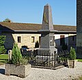
War memorial


population
| Population development | |
|---|---|
| year | Residents |
| 1962 | 164 |
| 1968 | 154 |
| 1975 | 159 |
| 1982 | 207 |
| 1990 | 216 |
| 1999 | 277 |
| 2006 | 247 |
With 277 inhabitants (January 1, 2017) Dambenoît-lès-Colombe is one of the small communities in the Haute-Saône department. After the population had decreased significantly in the first half of the 20th century (in 1881 there were still 486 people on today's municipality), population growth has been recorded again since the beginning of the 1970s. Only in the last few years has there been a further downward trend.
Economy and Infrastructure
Until well into the 20th century, Dambenoît-lès-Colombe was mainly a village characterized by agriculture (arable farming, fruit growing and cattle breeding) and forestry. Today there are some local small businesses. In the last few decades the village has transformed into a residential community. Many workers are therefore commuters who work in the larger towns in the area.
The village is located off the major thoroughfares on a department road that leads from Adelans to La Chapelle-lès-Luxeuil. Further road connections exist with Velleminfroy and Citers.