
Gouhenans
| Gouhenans | ||
|---|---|---|
|
||
| region | Bourgogne-Franche-Comté | |
| Department | Haute-Saône | |
| Arrondissement | Lure | |
| Canton | Villersexel | |
| Community association | Pays de Villersexel | |
| Coordinates | 47 ° 36 ' N , 6 ° 28' E | |
| height | 277-381 m | |
| surface | 8.45 km 2 | |
| Residents | 388 (January 1, 2017) | |
| Population density | 46 inhabitants / km 2 | |
| Post Code | 70110 | |
| INSEE code | 70271 | |
 Gouhenans, view of the church and castle |
||

Gouhenans is a commune in the French department of Haute-Saône in the region Bourgogne Franche-Comté .
geography
Gouhenans is located at an altitude of 299 m above sea level, seven kilometers north-northeast of Villersexel and about 24 kilometers east of the city of Vesoul (as the crow flies). The village extends in the hollow of the village stream at the east foot of the Mont, east of the valley of the Ognon and on the southern edge of the plain of Lure.
The area of the 8.45 km² municipal area comprises a section of the gently undulating landscape east of the Ognon Valley. The central part of the area is drained from the Dorfbach northwards to the Rahin . This marks the northern boundary of the municipality before it flows into the Ognon. The western part is occupied by the one kilometer wide and two kilometer long ridge of the Mont , on which the highest peak of Gouhenans is reached at 381 m. It is made up of a layer of limestone from the middle Jurassic period . In the south, the lowland of the Ruisseau de la Saline forms the border that feeds its water to the Ognon. The area is mainly used for agriculture. With a narrow strip, the community area extends to the northeast on a plateau that is an average of 300 m and the subsoil consists mainly of sandy-marly layers of the Lias .
The settlement of La Saline de Gouhenans (295 m) in the headwaters of the Ruisseau de la Saline belongs to Gouhenans . Neighboring municipalities of Gouhenans are Le Val-de-Gouhenans and Vouhenans in the north, La Vergenne and Athesans-Étroitefontaine in the east, Villafans and Longevelle in the south and Les Aynans in the west.
history

Gouhenans is mentioned for the first time in 1186. In the Middle Ages, Gouhenans formed the center of a rule that was dependent on the Lords of Granges . The noble family of the de Gouhenans died out in the 15th century. The castle was sacked several times, including by the Lorraine in 1472 and by the Swedes in 1636 during the Thirty Years' War. Together with Franche-Comté , the village finally came to France with the Peace of Nijmegen in 1678. In 1819, salt deposits were discovered near Gouhenan's. This created the industrial estate of La Saline de Gouhenans, which also had a glassworks and coal mining was carried out (17 shafts active between 1826 and 1916). With the opening of the railway line from Lure to Villersexel, the place was connected to the French railway network. The saltworks ceased operations in 1936. Since 2000 Gouhenans has been a member of the community association Communauté de communes du Pays de Villersexel, which comprises 33 villages .
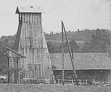
Shaft 13
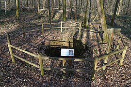
Shaft 15
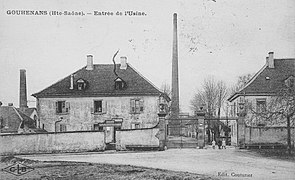
Saltworks


Attractions
The church of Gouhenans was largely rebuilt in 1680, using components from the previous medieval building. The remarkable furnishings include the statue of the Blessed Virgin and Child from the 15th century as well as furniture and statues from the 16th to 18th centuries.
The castle shows components from different epochs, some of which go back to the 15th century. Various houses from the 17th to 19th centuries in the traditional Haute-Saône style have been preserved in the town center.
population
| Population development | |
|---|---|
| year | Residents |
| 1962 | 463 |
| 1968 | 391 |
| 1975 | 391 |
| 1982 | 420 |
| 1990 | 362 |
| 1999 | 373 |
With 388 inhabitants (January 1, 2017), Gouhenans is one of the small communities in the Haute-Saône department. After the number of inhabitants had decreased significantly in the first half of the 20th century (in 1906 there were still 774 people), only relatively minor fluctuations have been recorded since the early 1970s.
Economy and Infrastructure
Gouhenans was early on not only influenced by agriculture (arable farming, fruit growing and cattle breeding) and forestry, but also by industry. Today there are various local small businesses. In the meantime, the village has also turned into a residential community. Many workers are therefore commuters who work in the larger towns in the area.
The village is located off the major thoroughfares on a department road that leads from Lure to Villafans. Other road links exist with Longevelle, Athesans-Étroitefontaine and La Vergenne.
Personalities
- Jean-François Carteaux (1751–1813), general in the French army