Écromagny
| Écromagny | ||
|---|---|---|
|
|
||
| region | Bourgogne-Franche-Comté | |
| Department | Haute-Saône | |
| Arrondissement | Lure | |
| Canton | Mélisey | |
| Community association | Haute Vallée de l'Ognon | |
| Coordinates | 47 ° 48 ' N , 6 ° 34' E | |
| height | 370-492 m | |
| surface | 6.80 km 2 | |
| Residents | 158 (January 1, 2017) | |
| Population density | 23 inhabitants / km 2 | |
| Post Code | 70270 | |
| INSEE code | 70210 | |
 Mairie from Écromagny |
||
Écromagny is a French commune in the department of Haute-Saône in the region Bourgogne Franche-Comté .
geography
Écromagny is located at an altitude of 477 m above sea level, 14 kilometers east-southeast of Luxeuil-les-Bains and about 36 kilometers northeast of the city of Vesoul (as the crow flies). The village extends in the northeastern part of the department, in the southwestern foothills of the Vosges , on the plateau des Mille Étangs .
The area of the municipality of 6.80 km² covers a section of the plateau landscape on the western edge of the Vosges. The area is occupied by a plateau that belongs to the Mille Étangs plateau . The plateau, which consists partly of crystalline bedrock and partly of red sandstone from the Lower Triassic , was shaped by glaciers during the Ice Ages. The landscape is therefore divided into knolls and hollows. It shows a loose structure of pastureland and forest, heathland and moors. In the basin there are numerous small lakes, which are predominantly of natural origin and formed during the Ice Age by glacier grinding. Some ponds were created or dammed higher by the monks for fish farming since the 11th century. The largest ponds on the parish are the Étang Pellevin , the Étang le Long Faing and the Étang des Gouttes .
The northern boundary is formed by the forest heights of Rang du Côte and Côte Meix . At 492 m, Écromagny's highest point is reached here. The Ruisseau de Chevigney (further on Ruisseau de la Mer ) rises in the woods northeast of the village and flows south and gradually deepens into the plateau with its alluvial lowland. The approximately 500 m wide flood plain marks the eastern border in sections. The entire municipality is part of the Ballons des Vosges Regional Nature Park .
Various farms belong to Écromagny, including Les Noies Jean (454 m) east of the Étang le Long Faing. Neighboring municipalities of Écromagny are La Voivre and Faucogney-et-la-Mer in the north, Ternuay-Melay-et-Saint-Hilaire in the east, Mélisey in the south and La Lanterne-et-les-Armonts in the west.
history
In the Middle Ages, Écromagny belonged to the Free County of Burgundy and in it to the area of the Bailliage d'Amont . Local rule was held by the Lords of Faucogney. The Lure Monastery has owned several ponds here since the 15th century. Together with Franche-Comté , the village finally came to France with the Peace of Nijmegen in 1678.
Attractions
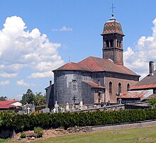
The village church of Écromagny was built in 1844 and houses a statue of Saint Martin from the 15th or 16th century and a painting of the Resurrection of Christ (19th century). Other attractions include a turreted house (16th century) and various farmhouses from the 17th to 19th centuries that show the traditional style of the southwestern Vosges.
population
| Population development | |
|---|---|
| year | Residents |
| 1962 | 209 |
| 1968 | 176 |
| 1975 | 150 |
| 1982 | 152 |
| 1990 | 158 |
| 1999 | 175 |
| 2006 | 177 |
With 158 inhabitants (January 1, 2017) Écromagny is one of the small communes of the Haute-Saône department. After the population had decreased significantly in the first half of the 20th century (373 people were still counted in 1886), only relatively small fluctuations have been recorded since the beginning of the 1970s.
Economy and Infrastructure
Écromagny is still predominantly a village characterized by agriculture (especially cattle and dairy farming, as well as arable and fruit growing), forestry and fish farming. Outside of the primary sector there are few jobs in town. Some workers are therefore commuters who work in the larger towns in the area.
The village is located off the major thoroughfares on a department road that leads from Mélisey to Faucogney-et-la-Mer . There are other road connections with Melay and La Lanterne.

