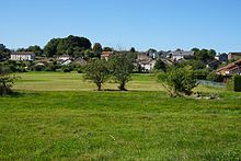
La Vaivre
| La Vaivre | ||
|---|---|---|
|
|
||
| region | Bourgogne-Franche-Comté | |
| Department | Haute-Saône | |
| Arrondissement | Lure | |
| Canton | Saint-Loup-sur-Semouse | |
| Community association | Haute Comté | |
| Coordinates | 47 ° 55 ' N , 6 ° 22' E | |
| height | 290–358 m | |
| surface | 3.04 km 2 | |
| Residents | 216 (January 1, 2017) | |
| Population density | 71 inhabitants / km 2 | |
| Post Code | 70320 | |
| INSEE code | 70512 | |
 Mairie La Vaivre |
||
La Vaivre is a commune in the French department of Haute-Saône in the region Bourgogne Franche-Comté .
geography
La Vaivre is located at an altitude of 337 m above sea level, eleven kilometers north of Luxeuil-les-Bains and about 36 kilometers north-northeast of the city of Vesoul (as the crow flies). The village extends in the north of the department, on a plateau south of the Augronne valley , on the edge of the heights of the Vôge .
The area of the 3.04 km² municipal area includes a section on the eastern edge of the plain of Saint-Loup-sur-Semouse. The central part of the area is occupied by the La Vaivre plateau, which is an average of 335 m and is mainly used for agriculture. It is made of red sandstone from the Lower Triassic . At 358 m, the highest point of La Vaivre is reached on the hill north of the village. Towards the north the plateau falls relatively steeply to the valley low of the Augronne, which marks the northern border. In the east, the boundary runs in the valley of the Ruisseau du Sapin , a side stream of the Augronne that separates the plateau from the western foothills of the Vosges . The western border runs along the edge of the forest of the Bois de Corbenay .
Neighboring municipalities of La Vaivre are Aillevillers-et-Lyaumont in the north, Fougerolles-Saint-Valbert with Fougerolles in the east and south and Corbenay in the west.
history
The discovery of a bronze hatchet indicates a very early settlement of the area. In the Middle Ages, La Vaivre belonged to the Free County of Burgundy and in it to the area of the Bailliage d'Amont . Local rule was held by the Lords of Faucogney. Together with Franche-Comté , the village finally came to France with the Peace of Nijmegen in 1678.
Attractions
The village is characterized by various farmhouses from the 18th and 19th centuries, which show the traditional style of the region.
population
| Population development | |
|---|---|
| year | Residents |
| 1962 | 270 |
| 1968 | 251 |
| 1975 | 268 |
| 1982 | 240 |
| 1990 | 213 |
| 1999 | 198 |
| 2006 | 214 |
With 216 inhabitants (January 1, 2017), La Vaivre is one of the small communities in the Haute-Saône department. During the entire 20th century, the population decreased continuously (in 1881 there were still 613 people). Stabilization has only been noted in recent years.
Economy and Infrastructure
La Vaivre is still today a predominantly agricultural (arable, fruit and cattle growing) village. Outside of the primary sector there are few jobs in town. Many workers are therefore commuters who work in the larger towns in the area.
The village is located off the major thoroughfares on a departmental road that leads from Aillevillers to Fougerolles. The nearest station on the railway line from Lure via Luxeuil-les-Bains to Épinal is in Aillevillers.

