
Granges-le-Bourg
| Granges-le-Bourg | ||
|---|---|---|

|
|
|
| region | Bourgogne-Franche-Comté | |
| Department | Haute-Saône | |
| Arrondissement | Lure | |
| Canton | Villersexel | |
| Community association | Pays de Villersexel | |
| Coordinates | 47 ° 34 ' N , 6 ° 35' E | |
| height | 290-453 m | |
| surface | 10.35 km 2 | |
| Residents | 387 (January 1, 2017) | |
| Population density | 37 inhabitants / km 2 | |
| Post Code | 70400 | |
| INSEE code | 70277 | |

|
||

Granges-le-Bourg is a municipality in the French department of Haute-Saône in the region Bourgogne Franche-Comté .
geography
Granges-le-Bourg is located at an altitude of 330 m above sea level, eleven kilometers east of Villersexel and about 17 kilometers west-northwest of the city of Montbéliard (as the crow flies). The village extends in the hilly landscape in the southeast of the department, on a hill east of the valley of the Scey , on the southwest edge of the heights of the Bois de Granges .
The area of the 10.35 km² large municipal area comprises a section of the hilly landscape between the valleys of Ognon and Doubs . The southern part of the area belongs to a basin that is drained westwards to the Scey by the Ruisseau du Pont du Rond and Ruisseau de Mouillère streams flowing in parallel . This forms the western municipal boundary over a short section. The hollow is mainly used for agriculture.
To the north, the municipal area extends into the extensive wooded area of the Bois de Granges . It is an average of 400 m plateau, which is subdivided by numerous erosion valleys of brooks in the headwaters of Scey and Rognon . At 453 m, the highest point in Granges-le-Bourg is reached here. The plateau forms the southwestern continuation of the Vosges and is mainly made of red sandstone .
Neighboring communities of Granges-le-Bourg are Faymont in the north, Saulnot in the east, Crevans-et-la-Chapelle-lès-Granges and Secenans in the south and Granges-la-Ville and Mignavillers in the west.
history
Granges is first mentioned in a document in 1105. The beginnings of the Granges rule, which at that time was one of the most important in the Free County of Burgundy, are still in the dark. The Lords of Granges probably built a strong fortified castle on the hill in the 11th century, around which the village developed. Since 1150 the lords of Granges were vassals of the Counts of Montbéliard. Together with Franche-Comté , the village finally came to France with the Peace of Nijmegen in 1678.
After the French Revolution , Granges-le-Bourg became the capital of the canton of the same name, which was abolished in 1801 and merged with the canton of Villersexel. A merger with the surrounding towns (La Chapelle-lès-Granges, Crevans, Granges-la-Ville, Mignafans, Mignavillers and Secenans) made Granges-le-Bourg into one large municipality in 1807. Granges-la-Ville, Mignafans and Mignavillers, in 1832 Crevans and Secenans and in 1853 La Chapelle-lès-Granges separated from this large municipality. Since 2000, Granges-le-Bourg has been a member of the community association Communauté de communes du Pays de Villersexel, which comprises 33 villages .
Attractions
The ruins of the medieval castle (11th to 12th centuries) have been preserved. The townscape is characterized by various medieval buildings: the Maison Racle sur le Treige in the Renaissance style dates from 1572, the Maison Gaudy also dates from the 16th century, and the Maison du Bailli from 1606 (Renaissance style) has a massive square tower. The Mairie (local government) is located in a building that was built from 1750 to 1751 as a court and prison. The chapel and the former lavoir (fountain, wash house and cattle trough) date from the 19th century. A wayside cross dates from 1718.

Maison Racle sur le Treige

Maison Gaudy, Monument historique
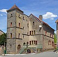
Maison du Bailli, Monument historique
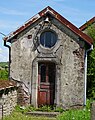
Granges-le-Bourg chapel


population
| Population development | |
|---|---|
| year | Residents |
| 1962 | 315 |
| 1968 | 287 |
| 1975 | 356 |
| 1982 | 330 |
| 1990 | 306 |
| 1999 | 313 |
| 2006 | 347 |
| 2016 | 380 |
With 387 inhabitants (January 1, 2017), Granges-le-Bourg is one of the small communities in the Haute-Saône department. After the population had decreased significantly in the first half of the 20th century (374 people were still counted in 1886), population growth was recorded again, especially during the 1950s. Since then, only relatively minor fluctuations have been recorded.
Economy and Infrastructure
Until well into the 20th century, Granges-le-Bourg was a village dominated by agriculture (arable farming, fruit growing and cattle breeding) and forestry. The water power of the streams used to be used to operate several mills. Today there are various local small businesses. In the meantime, the village has also turned into a residential community. Many employed people are therefore commuters who go to work in the larger towns in the vicinity and in the Belfort-Montbéliard agglomeration.
The village is located away from the major thoroughfares, but is easily accessible from the main road D9, which leads from Héricourt to Villersexel. Other road connections exist with Saulnot, Granges-la-Ville and Secenans.