
Magnivray
| Magnivray | ||
|---|---|---|
|
||
| region | Bourgogne-Franche-Comté | |
| Department | Haute-Saône | |
| Arrondissement | Lure | |
| Canton | Mélisey | |
| Community association | Pays de Luxeuil | |
| Coordinates | 47 ° 47 ' N , 6 ° 28' E | |
| height | 294-361 m | |
| surface | 4.76 km 2 | |
| Residents | 168 (January 1, 2017) | |
| Population density | 35 inhabitants / km 2 | |
| Post Code | 70300 | |
| INSEE code | 70314 | |
 Municipal administration (mairie) |
||

Magnivray is a municipality in the French department of Haute-Saône in the region Bourgogne Franche-Comté .
geography
Magnivray is located at an altitude of 345 m above sea level, eight kilometers east-southeast of Luxeuil-les-Bains and about 30 kilometers northeast of the city of Vesoul (as the crow flies). The village extends in the northeastern part of the department, on the western cap of the Plateau des Mille Étangs , on the edge of the Luxeuil plain.
The area of the 4.76 km² municipality covers a section of the southwestern Vosges foothills. The main part of the area is taken up by a gently sloping south-west slope of the Mille Étangs plateau , which is mainly used for agriculture. The Lambier and its source streams provide drainage to the lantern . There are numerous ponds here, most of which were dammed (some by monks as early as the 11th century) and are used for fish farming.
Larger forest areas can be found along the municipal boundaries, in the west of the Grand Bois and the Vay de Brest , in the north of the Corrin and in the northeast of Les Époisses . At 361 m, the highest point of Magnivray is reached on the edge of the Les Époisses forest . In geological and tectonic terms, the terrain consists of red sandstone from the Lower Triassic . In the far west, the municipal area extends into the alluvial plain of Luxeuil, which is an average of 300 m.
Magnivray includes the following settlements:
- Les Fouillies de Magnivray (313 m) on the edge of the Luxeuil plain
- La Maison Rouge (325 m) on the slope below Magnivray
Neighboring municipalities of Magnivray are La Bruyère and La Corbière in the north, Belmont in the east, Rignovelle and Citers in the south and Esboz-Brest in the west.
history
In the Middle Ages Magnivray belonged to the Free County of Burgundy and in it to the area of the Bailliage d'Amont . Local rule was held by the Lords of Faucogney. Together with Franche-Comté , the village finally came to France with the Peace of Nijmegen in 1678. Today Magnivray is a member of the community association Communauté de communes du Pays de Luxeuil, which comprises 13 localities .
Attractions
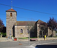
The village church of the Assumption ( Église de l'Assomption ) by Magnivray was rebuilt in the 19th century. On a house in the village there is a group of statues of the Trinity from the 16th or 17th century.
- Church of the Assumption in Magnivray


population
| Population development | |
|---|---|
| year | Residents |
| 1962 | 195 |
| 1968 | 159 |
| 1975 | 151 |
| 1982 | 161 |
| 1990 | 153 |
| 1999 | 155 |
| 2006 | 160 |
With 168 inhabitants (January 1, 2017) Magnivray is one of the small communities in the Haute-Saône department. After the population had decreased significantly in the first half of the 20th century (414 people were still counted in 1896), only minor fluctuations have been recorded since the early 1970s.
Economy and Infrastructure
Until well into the 20th century, Magnivray was primarily a village characterized by agriculture (arable farming, fruit growing and cattle breeding) and fish farming. Today there are some local small businesses. In the last few decades the village has transformed into a residential community. Many workers are therefore commuters who work in the larger towns in the area.
The village is located off the major thoroughfares on a departmental road that leads from Lure to Breuchotte . Other road connections exist with Saint-Sauveur, La Corbière and Belmont.