Lantern
| Lantern | ||
|
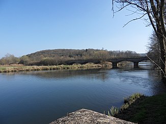
The lantern at Faverney |
||
| Data | ||
| Water code | FR : U04-0400 | |
| location | France | |
| River system | Rhône | |
| Drain over | Saône → Rhône → Mediterranean | |
| source | in the municipality of La Lanterne-et-les-Armonts 47 ° 47 ′ 48 ″ N , 6 ° 32 ′ 12 ″ E |
|
| Source height | approx. 450 m | |
| muzzle | in the municipality of Conflandey in the Saône Coordinates: 47 ° 43 '58 " N , 6 ° 2' 39" E 47 ° 43 '58 " N , 6 ° 2' 39" E |
|
| Mouth height | approx. 210 m | |
| Height difference | approx. 240 m | |
| Bottom slope | approx. 3.8 ‰ | |
| length | 64 km | |
| Catchment area | 1044 km² | |
| Outflow at the Fleurey-lès-Faverney gauge |
MQ |
21.8 m³ / s |
| Right tributaries | Breuchin , Rôge , Sémouse | |
|
The lantern in Lantenot |
||
The Lanterne is a river in France that runs in the Haute-Saône department in the Bourgogne-Franche-Comté region .
geography
course
The Lanterne has its source in the western part of the Ballons des Vosges Regional Nature Park , in the municipality of La Lanterne-et-les-Armonts , in the Plateau des Mille Étangs lake district . It initially drains in a south-westerly direction, then turns to the north-west and flows again in its lower reaches towards the south-west. After 64 kilometers it flows into the Saône as a left tributary in the municipality of Conflandey .
Tributaries
- Gravissière (left)
- Lambier (right)
- Ruisseau du Vay de Brest (right)
- Ruisseau de Perchie (left)
- Mauvais Treil (left)
- Ruisseau du Bas (left)
- Ruisseau de la Mouroie (left)
- Ruisseau de la Prairie (left)
- Ruisseau des Vaux (right)
- Breuchin (right)
- Ravonnage (right)
- Rôge (right)
- Ruisseau de Rohan (left)
- Ruisseau de l'Etang Monsier (left)
- Ruisseau de la Prairie (left)
- Semouse (right)
- Ruisseau de Chaufours (left)
- Ruisseau de Biffotte (right)
- Ruisseau des Canes (right)
- Ruisseau de Courcelles (right)
- Ruisseau de la Raie des Combes (left)
- Noue de la Marcelle (right)
- Creusotte (left)
- Noe Doit (right)
- Ruisseau de en la Cour (left)
- Ruisseau de Ronde Tête (right)
- Noue Rouge (right)
Places on the river
See also
Web links
Commons : Lanterne - collection of pictures, videos and audio files

