
Plateau des Mille Étangs
The Plateau des Mille Étangs (literally Plateau of the Thousand Ponds ) is a geographical area of over 220 square kilometers in the northeastern part of the Haute-Saône in the region Bourgogne Franche-Comté in France .
At the end of the last glacial period 12,000 years ago, the retreat of the Moselle glacier over the Vosges formed an overburden that covered the region and favored the formation of moors and swamps on three plateaus of different heights. In the Middle Ages, the space was changed by people who developed fish farming there by creating ponds. These water reserves were then used by the local textile and paper industries in the 19th and 20th centuries.
At the beginning of the 21st century, this region, which is largely covered with forest, is of ecological interest. This is mainly due to their wetlands, which are home to remarkable biotopes that are adapted to a cold and humid environment. This region of a thousand ponds is recognized as the “Zone Naturelle d'intérêt écologique, Faunistique et floristique” (ZNIEFF). Most of it is contained in a Natura 2000 area and in the Ballons des Vosges Regional Nature Park . In the south is the regional nature reserve of the peat bog Grande Pile. The Thousand Ponds also have a touristic significance due to their landscapes, which give them the nickname "Petite Finlande" in analogy to the Finnish " Thousand Lakes ".
- gallery
Forest

Meadow with Ballon de Servance in the background

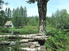
Typical pond with a fisherman's hut

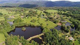
Étang des Grands Prés at La Voivre

Étang de l'Oranger at Corravillers
Several ponds at Servance-Miellin


Web links
- Website Mille Étangs (French)
Coordinates: 47 ° 49 ′ 0 ″ N , 6 ° 37 ′ 29 ″ E
Individual evidence
- ↑ Natacha Ferrer, Plateau des mille étangs - FR4301346 - document d'objectif, Parc naturel régional des Ballons des Vosges, 2008, 109 p. (French)
- ↑ Denis Mathis, "Les enjeux des paysages d'eau dans la construction du Pays des Mille Étangs", Revue Géographique de l'Est, vol.56 / n ° 1-2, 2016, p. 1-18. (French)
- ↑ Le plateau des Mille Étangs, Natura 2000 , Inventaire national du patrimoine naturel (French)