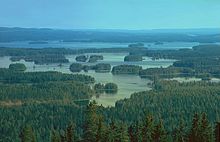
Finnish Lake District
The Finnish Lake District is located in southeastern Finland ; but small parts also extend to Russia . The area has no distinctive geomorphological boundaries, but is generally considered to be the catchment area of the Kokemäenjoki , Kymijoki and Vuoksi rivers .
Emergence
The lake basins of the Finnish Lake District were carved out by the glacier masses during the Vistula Ice Age. After the ice retreated, moraine hollows , glacier basins and older depressions and tectonic trenches were filled with meltwater, most of which were still connected to the Ancylussee , a huge meltwater lake on the site of today's Baltic Sea. As a result of the postglacial land uplift , more and more of these basins were separated from this meltwater lake over the millennia. The formation of the Salpausselkä moraines in the south of the region and the Suomenselkä in the northeast dammed large amounts of meltwater and rainwater in the east of Finland, so that 6,000 years ago a lake more than 400 km long was formed from today's Iisalmi in the north to Salpausselkä. Only when the rivers Kymijoki and Vuoksi broke through 6,000 resp. 5,000 years ago the lake system found a natural runoff, so that the water level fell and today's topography began to emerge. The land uplift is a process that continues to this day, which can silt up the closure of poor seas within a generation, so that a new lake is created.
topography
The moor and wooded lake district is the largest lake district in Europe with an area of well over 100,000 km².
The number of lakes in the Finnish Lake District varies with the definition of the term lake . According to the official Finnish census, which includes standing inland water under a lake with a size ≥ 0.05 hectares , the number of lakes in the region is around 42,200. Many lakes are divided into numerous bays, basins and arms of the lake by water strait, which in turn are often viewed as independent lakes. The largest and most widely branched lake is the Saimaa lake system with around 4,370 km² .
The lakes in the region are mostly quite shallow, the deepest and most water-rich in terms of volume is the Päijänne with a maximum depth of 95 m .
The largest lakes are connected by rivers, water straits and artificial canals, so that the lake district also plays a significant role for inland shipping . The waterway between Lappeenranta in the south and Varkaus in the north of the lake district is about 230 km long and naturally without canals and locks at a level of about 76 m.
literature
- Esko Kuusisto: Lake District in Finland . In: Matti Seppälä (ed.): The Physical Geography of Fennoscandia. Oxford University Press 2005. pp. 283-296.
Remarks
Coordinates: 61 ° 20 ′ 28 ″ N , 28 ° 0 ′ 39 ″ E


