Ballon de Servance
| Ballon de Servance | ||
|---|---|---|
|
The Ballon de Servance seen from the Alsatian Belchen |
||
| height | 1216 m | |
| location | Haute-Saône , the Vosges region Grand Est region Bourgogne Franche-Comte , France | |
| Mountains | Vosges | |
| Coordinates | 47 ° 49 '48 " N , 6 ° 47' 34" E | |
|
|
||
The Ballon de Servance is a mountain in the southern Vosges and at the same time the highest point of the Vosges Saônoises . It has a height of 1216 meters. The mountain is located near the borders of the departments of Haut-Rhin (Upper Rhine) and Territoire de Belfort on the Genze of the departments of Vosges and Haute-Saône in the regions Grand Est and Bourgogne Franche-Comté in the Regional Natural Park of Ballons des Vosges yet enjoying the Réserve naturelle national des balloon comtois .
location
The Ballon de Servance is located west of the Alsatian Belchen (French: Ballon d'Alsace) and separated from the Col du Stalon on the ridge that extends north-northeast to south-southwest from Saint-Maurice-sur-Moselle to Belfahy and south of the mountain still has several elevations that reach over 1000 meters and sometimes over 1100 meters in height. The mountain lies on the watershed between the Mediterranean and the North Sea.
tourism
Once a year, the “Les 3 ballons” cycling marathon passes the mountain, which is not very well developed for tourists, on the D 16 département road, which was built in the 19th century for military reasons. Access is also possible from the west via the Col des Croix (altitude 680 meters). The long-distance hiking trails GR 7 and GR 59 in the GR long-distance hiking network , which are marked by the Club Vosgien (Vosges Club), lead past the Ballon de Servance . A hotel built on the summit in 1880 and mainly used by the military has disappeared. The small refuge Refuge Sailley is located at the nearby Col du Luthier .
Military use
Fort Scherer was built on the Ballon de Servance after Alsace was ceded to the German Empire between 1877 and 1879 , from which the Alsatian Belchen could be shot at. A military radar system has been located on the summit since 1951, to which a closed branch road leads.
Plane crash
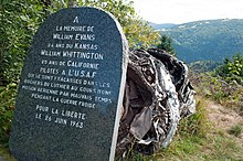
Two American military aircraft collided with the mountain in June 1963; the two pilots were killed. A memorial stone commemorates them.
Individual evidence
- ↑ http://www.quaeldich.de/paesse/ballon-de-servance/
- ^ Reference in the article Ballon de Servance in the French Wikipedia
- ↑ http://www.quaeldich.de/paesse/ballon-de-servance/


