La Basse-Vaivre
| La Basse-Vaivre | ||
|---|---|---|

|
|
|
| region | Bourgogne-Franche-Comté | |
| Department | Haute-Saône | |
| Arrondissement | Lure | |
| Canton | Jussey | |
| Community association | Haute Comté | |
| Coordinates | 47 ° 57 ' N , 6 ° 3' E | |
| height | 227-268 m | |
| surface | 3.54 km 2 | |
| Residents | 37 (January 1, 2017) | |
| Population density | 10 inhabitants / km 2 | |
| Post Code | 70210 | |
| INSEE code | 70051 | |
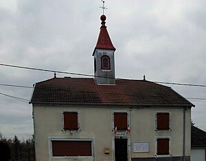
 Mairie La Basse-Vaivre |
||
La Basse-Vaivre is a commune in the French department of Haute-Saône in the region Bourgogne Franche-Comté .
geography
La Basse-Vaivre is located at an altitude of 242 m above sea level, 18 kilometers northeast of Jussey and about 37 kilometers north-northwest of the city of Vesoul (as the crow flies). The street row village extends in the far north of the department, slightly elevated on the southern edge of the Côney valley , on the southern edge of the ridge of Mont Paron .
The area of the 3.54 km² municipal area covers a section in the gently undulating landscape east of the upper Saône valley . The western and northern borders always run along the Côney, which provides drainage to the Saône. The waterway of the Canal de l'Est runs parallel to the north of the river . The floodplain is on average 230 m and has a maximum width of one kilometer. From the course of the river, the community area extends southeast over the floodplain to the adjacent Frisémont plateau. Here, at 268 m, the highest point of La Basse-Vaivre is reached. The eastern boundary to the Bois de Foignouse forms a side stream of the Côney. From a geological and tectonic point of view, the terrain consists of alternating layers of sandy-marl and calcareous sediments that were deposited during the Lias ( Lower Jurassic ). Shell limestone from the Triassic comes to light in various places .
Neighboring municipalities of La Basse-Vaivre are Passavant-la-Rochère and Selles in the north, Montdoré in the east and Demangevelle in the south and west.
history
The discovery of an ax from the Bronze Age indicates an early settlement of the area. In the Middle Ages, La Basse-Vaivre belonged to the Free County of Burgundy and in it to the area of the Bailliage d'Amont . The lords of Vauvillers held local rule. Together with Franche-Comté , the village finally came to France with the Peace of Nijmegen in 1678.
Attractions
Local attractions include the Mairie (community center), the Calvaire and a lavoir from the late 18th century that was once used as a wash house and cattle trough.
population
| Population development | |
|---|---|
| year | Residents |
| 1962 | 88 |
| 1968 | 83 |
| 1975 | 56 |
| 1982 | 48 |
| 1990 | 52 |
| 1999 | 37 |
| 2006 | 44 |
With 45 inhabitants (2007), La Basse-Vaivre is one of the smallest communities in the Haute-Saône department. After the population had decreased markedly in the first half of the 20th century (210 people were still counted in 1881), only slight fluctuations have been recorded since the mid-1970s.
Economy and Infrastructure
For a long time, La Basse-Vaivre was predominantly a village characterized by agriculture (agriculture, viticulture and cattle breeding). At the beginning of the 20th century, economic life was characterized by an ironworks and a pottery. Today there are few jobs in the village outside of the primary sector. Many workers are therefore commuters who work in the larger towns in the area.
The village is located off the major thoroughfares on a department road that leads from Demangevelle to Selles. Further road connections exist with Vauvillers and Passavant-la-Rochère.
