Magnoncourt
| Magnoncourt | ||
|---|---|---|
|
|
||
| region | Bourgogne-Franche-Comté | |
| Department | Haute-Saône | |
| Arrondissement | Lure | |
| Canton | Saint-Loup-sur-Semouse | |
| Community association | Haute Comté | |
| Coordinates | 47 ° 54 ' N , 6 ° 17' E | |
| height | 242-291 m | |
| surface | 6.67 km 2 | |
| Residents | 418 (January 1, 2017) | |
| Population density | 63 inhabitants / km 2 | |
| Post Code | 70800 | |
| INSEE code | 70315 | |
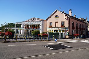
 Mairie and Magnoncourt School |
||
Magnoncourt is a municipality in the French department of Haute-Saône in the region Bourgogne Franche-Comté .
geography
Magnoncourt is located at an altitude of 252 m above sea level, one kilometer northeast of Saint-Loup-sur-Semouse and about 32 kilometers north-northeast of the city of Vesoul (as the crow flies). The village extends in the far north of the department, on a plain, on the edge of the Vôge plateau , near the mouth of the Ruisseau du Chânet in the Sémouse .
The area of the 6.67 km² municipal area includes a section in the gently undulating landscape on the edge of the Vôge. The main part of the area is occupied by the alluvial plain of the Semouse, which averages 245 m. The Ruisseau du Chânet stream enters this plain from the north . The plain is flanked in the west by a plateau consisting of shell limestone from the Middle Triassic , which is covered by the forest of the Bois des Gouttes (up to 280 m). The western boundary is the Ruisseau des Lauchères . To the north, the municipal area extends into the valley of the Ruisseau le Petit (tributary of the Ruisseau du Chânet), which is dammed up into a 5-hectare pond. In the northeast, the communal soil extends into the Bois du Rogney , in which Magnoncourt's highest elevation is reached at 291 m. This hill is made of red sandstone from the Lower Triassic.
Neighboring municipalities of Magnoncourt are Fleurey-lès-Saint-Loup and Aillevillers-et-Lyaumont in the north, Corbenay in the east and Saint-Loup-sur-Semouse in the south and west.
history
Remains of a Roman traffic route in the Bois du Rogney testify to an early inspection and settlement of the area. In the Middle Ages Magnoncourt belonged to the Free County of Burgundy and in it to the area of the Bailliage d'Amont . The lords of Saint-Loup held local rule. Together with Franche-Comté , the place finally came to France with the Peace of Nijmegen in 1678. In 1783 and 1784 Magnoncourt was hit by two serious village fires. Ecclesiastically, the place belongs to the parish of Saint-Loup-sur-Semouse.
population
| Population development | |
|---|---|
| year | Residents |
| 1962 | 367 |
| 1968 | 452 |
| 1975 | 507 |
| 1982 | 453 |
| 1990 | 440 |
| 1999 | 452 |
| 2006 | 441 |
With 418 inhabitants (January 1, 2017) Magnoncourt is one of the smaller communities in the Haute-Saône department. After the population had decreased significantly in the first half of the 20th century (there were still 545 people counted in 1906), after a slight increase in population during the 1960s, only minor fluctuations have been recorded since the mid-1970s. Today the settlement area of Magnoncourt has almost completely merged with that of Saint-Loup-sur-Semouse.
Economy and Infrastructure
For a long time, Magnoncourt was mainly characterized by agriculture (arable farming, fruit growing and cattle breeding) and forestry. Since the 1960s, a commercial and industrial zone has developed on the municipal border with Saint-Loup-sur-Semouse. Various companies have settled here, including a cleaning company and a chair factory. In the last few decades the village has also turned into a residential community. Many workers are therefore commuters who work in the larger towns in the area.
The village is well developed in terms of traffic. It is close to the main road D417 that goes from Luxeuil-les-Bains to Bourbonne-les-Bains . There are other road connections with Bains-les-Bains , Saint-Loup-sur-Semouse and Aillevillers.
