
Bourbonne-les-Bains
| Bourbonne-les-Bains | ||
|---|---|---|

|
|
|
| region | Grand Est | |
| Department | Haute-Marne | |
| Arrondissement | Langres | |
| Canton | Bourbonne-les-Bains (main town) | |
| Community association | Pays de Chalindrey, de Vannier Amance et de la Région de Bourbonne-les-Bains | |
| Coordinates | 47 ° 57 ' N , 5 ° 45' E | |
| height | 245-444 m | |
| surface | 64.93 km 2 | |
| Residents | 2,073 (January 1, 2017) | |
| Population density | 32 inhabitants / km 2 | |
| Post Code | 52400 | |
| INSEE code | 52060 | |
| Website | www.bourbonne.com | |
_2014-06-20_16.40.35.jpg) Partial view of the city |
||

Bourbonne-les-Bains is a French commune with 2,073 inhabitants (as of January 1, 2017) in the Haute-Marne department in the Grand Est region ; it belongs to the Arrondissement of Langres .
location
Bourbonne-les-Bains is located in a rural region on the border with the Vosges department . The A31 autoroute runs ten kilometers to the west between Langres and Toul .
history
In Celtic times, the Lingons lived in the region around the city. The place is named after the Celtic god of healing Borvo , so the Celts already knew about the healing power of the warm springs in Bourbonne. The Romans also recognized the beneficial effects of water and built thermal baths in the city . From the 14th to the 17th centuries, the water brought the lords of Bourbonne a rich income.
On May 1st, 1717 a fire destroyed the city. A royal military hospital was opened in 1735, and a thermal bath in 1783. Bourbonne experienced a tourist boom, which intensified with the advent of the railroad in the 19th century. Between 1977 and 1979 a large thermal bath was built in the city. During the construction work, numerous traces of earlier settlements came to light, including the remains of baths and porticos, a tub made of lead, rooms with hypocausts and statues.
Bourbonne-les-Bains historically belongs to the Bailliage de Langres within the province of Champagne . The place belonged from 1793 to 1801 to the District Bourbonne. It has also been the capital of the canton of Bourbonne (-les-Bains) since 1793 .
In 1972, the two previously independent municipalities of Genrupt (1968: 96 inhabitants) and Villars-Saint-Marcellin (1968: 171 inhabitants) were incorporated.
Population development
The community already had more than 3000 inhabitants before 1800. By 1851 the number of residents - from the 10 years between 1821 and 1831 - grew steadily (1793–1851: + 33.1%) and raised the population to more than 4000 people. Until 1906, with the exception of 1856, the population remained at over 4000 people. The historical high was in 1881. Between 1906 and 1926 there was a marked decline in population (1906–1926: - 28%). Thereafter the population decreased only slightly until 1962 (1926–1962: - 9.6%). Between 1962 and 1975 there was a strong growth phase of 18.3% (partly due to incorporations). Since 1982, many people have emigrated to other regions again (1982–2013: - 30.9%). The population is currently at an all-time low and the municipality has lost more than half of its residents since its peak (1881–2013: -51.5%).
| 1793 | 1800 | 1806 | 1821 | 1831 | 1836 | 1841 | 1846 | 1851 | 1856 | 1861 | 1866 | 1872 | 1876 | 1881 | 1886 | 1891 | 1896 |
|---|---|---|---|---|---|---|---|---|---|---|---|---|---|---|---|---|---|
| 3107 | 3136 | 3306 | 3380 | 3272 | 3551 | 3700 | 3844 | 4135 | 3810 | 4080 | 4053 | 4274 | 4039 | 4406 | 4322 | 4148 | 4156 |
| 1901 | 1906 | 1911 | 1921 | 1926 | 1931 | 1936 | 1946 | 1954 | 1962 | 1968 | 1975 | 1982 | 1990 | 1999 | 2006 | 2012 | 2013 |
|---|---|---|---|---|---|---|---|---|---|---|---|---|---|---|---|---|---|
| 4038 | 4021 | 3707 | 3215 | 2896 | 2808 | 2827 | 2709 | 2702 | 2617 | 2912 | 3095 | 3022 | 2764 | 2495 | 2275 | 2172 | 2139 |

Attractions
An important attraction of the city is the local museum, in which numerous archaeological objects are exhibited, which document the history of the place and its importance as one of the largest baths in northern Gaul in Gallo-Roman times. There are also remains of the Gallo-Roman baths in the village. Other attractions are:
- City Church of Notre-Dame-de-son-Assomption (. Partly 12-13 century, partly 19th century)
- Notre-Dame-en-son-Assomption village church from 1781 in the Genrupt district
- Saint-Marcellin village church in the Villars-Saint-Marcellin district (partly 12th century; partly 19th century)
- Notre-Dame-de-la-Sallette chapel from 1856 in the Villars-Saint-Marcellin district
- Notre-Dame-des-Eaux chapel
- La Porte-Galons
- Park by the town hall (Mairie) (French style), Arboretum of Montmorency (English style)
- La Bannie animal park on the Route du Coiffy

Town hall (Mairie) of Bourbonne-les-Bains

Remnant from Gallo-Roman times

Town church of Bourbonne-les-Bains

Village church of Villars-Saint-Marcellin
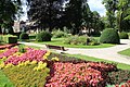
Park by the town hall

Memorial to the Fallen

House in Bourbonne-les-Bains

_2014-06-20_17.02.21.jpg)
_2014-06-20_14.59.25.jpg)


Town twinning
- Weiskirchen in Saarland
economy
The city lives from spa tourism. In addition to health tourism , an extensive hotel industry has settled in the city. A large casino has been added in recent years.
Personalities
- Maurice Constantin-Weyer (1881–1964), writer, winner of the Prix Goncourt 1928
- Denis Diderot stayed here in 1770 and wrote Les Deux Amis de Bourbonne.
Individual evidence
- ↑ a b History of the City
- ↑ Description and photos of the city church
- ↑ Description and photos of the Genrupt village church
- ↑ Description and photos of the village church of Villars-Saint-Marcellin
- ^ Description and photos of the chapel of Villars-Saint-Marcellin