
Fresnes-sur-Apance
| Fresnes-sur-Apance | ||
|---|---|---|

|
|
|
| region | Grand Est | |
| Department | Haute-Marne | |
| Arrondissement | Langres | |
| Canton | Bourbonne-les-Bains | |
| Community association | Pays de Chalindrey, de Vannier Amance et de la Région de Bourbonne-les-Bains | |
| Coordinates | 47 ° 57 ' N , 5 ° 50' E | |
| height | 238-393 m | |
| surface | 16.47 km 2 | |
| Residents | 148 (January 1, 2017) | |
| Population density | 9 inhabitants / km 2 | |
| Post Code | 52400 | |
| INSEE code | 52208 | |

Fresnes-sur-Apance is a French commune with 148 inhabitants (as of January 1, 2017) in the Haute-Marne department in the Grand Est region ; it belongs to the Arrondissement of Langres .
geography
Fresnes-sur-Apance is located on the Apance , around 27 kilometers east-southeast of the city of Chaumont in the southeast of the Haute-Marne department on the border with the Vosges department .
history
The municipality was part of the Bailliage de Vesoul within Franche-Comté until 1789 . The mechanization of agriculture led to heavy emigration in the late 19th and 20th centuries. The place was historically part of the Bailliage de Vesoul within the province of Franche-Comté. Fresnes-sur-Apance belonged to the Bourbonne district from 1793 to 1801. Also from 1793 to 1801 to the canton of Fresnes-sur-Apance and from 1801 to the canton of Bourbonne-les-Bains .
Population development
| year | 1793 | 1821 | 1841 | 1856 | 1872 | 1962 | 1968 | 1975 | 1982 | 1990 | 1999 | 2006 | 2017 |
| Residents | 1283 | 1146 | 1281 | 1101 | 1081 | 343 | 300 | 244 | 243 | 217 | 170 | 157 | 148 |
| Sources: Cassini and INSEE | |||||||||||||
Attractions
- Village church of Saint-Julien from 1770–1773
- Notre-Dame-de-Pitié chapel from 1855
- Memorial to the Fallen

View of the village with the church
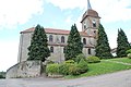
Saint-Julien village church

Fresnes-sur-Apance village fountain

Community House (Mairie) of Fresnes-sur-Apance

Memorial to the Fallen
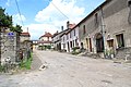
Partial view of the village


