
Farincourt
| Farincourt | ||
|---|---|---|
|
||
| region | Grand Est | |
| Department | Haute-Marne | |
| Arrondissement | Langres | |
| Canton | Chalindrey | |
| Community association | Pays de Chalindrey, de Vannier Amance et de la Région de Bourbonne-les-Bains | |
| Coordinates | 47 ° 42 ' N , 5 ° 41' E | |
| height | 240-360 m | |
| surface | 5.08 km 2 | |
| Residents | 39 (January 1, 2017) | |
| Population density | 8 inhabitants / km 2 | |
| Post Code | 52500 | |
| INSEE code | 52195 | |
 old postcard from Farincourt (early 20th century) |
||

Farincourt is a French commune with 39 inhabitants (as of January 1, 2017) in the Haute-Marne department in the Grand Est region (until 2015 Champagne-Ardenne ). The municipality belongs to the Arrondissement Langres and the municipality association Pays de Chalindrey, de Vannier Amance et de la Région de Bourbonne-les-Bains, founded in 2016 . The inhabitants are called Farincourtois .
geography
The municipality of Farincourt is located in the southeast of the Langres plateau , about 35 kilometers southeast of Langres and 40 kilometers west-northwest of Vesoul . To the west of the 5.08 km² community, the Bois de Farincourt forest is the highest point at 360 meters above sea level. A special feature is the Rigotte river , which, coming from the north, disappears into the calcareous soil just below the village of Farincourt ( Perte de la Rigotte ). The water squeezes through an extensive karst cave system and only comes to light six kilometers further south in Fouvent-le-Bas ( résurgence ). From there, the water reaches the Vannon in the Saône catchment area . The municipality of Farincourt borders the Haute-Saône department to the east and south . Farincourt is surrounded by the neighboring communities Voncourt in the north, Bourguignon-lès-Morey in the east, Fouvent-Saint-Andoche in the south and Valleroy in the west.
Population development
| year | 1962 | 1968 | 1975 | 1982 | 1990 | 1999 | 2006 | 2016 |
| Residents | 102 | 151 | 111 | 89 | 68 | 51 | 56 | 39 |
| Source: Cassini and INSEE | ||||||||
Attractions
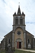
- Saint-Mathieu church
- former iron foundry (a first blast furnace was put into operation in 1671, closed in 1981)
- Perte de la Rigotte , river seepage
- Croix de la Corne de l'Étang, Croix de Valleroy and another two floor crosses
- Cave Trou des Andouzoirs
- Saint-Mathieu church


Economy and Infrastructure
For a long time, Farincourt was primarily a village characterized by agriculture (arable farming and cattle breeding) and forestry. An iron foundry for the production of stoves and stoves existed in the community until 1981. The first blast furnace was already in operation in 1671. Today there are a few local small-scale businesses and two farms (growing grain, raising livestock). Some workers are commuters who work in the larger towns in the area.
The village is away from the major thoroughfares. Ten kilometers north of Farincourt, Route nationale 19 runs from Langres to Vesoul . There are connections to the A 31 autoroute near Langres .
supporting documents
- ↑ Farincourt on cassini.ehess.fr (French)
- ↑ Farincourt on INSEE
- ↑ Rigotte infiltration (French)
- ↑ Farms on annuaire-mairie.fr (French)