Violot
| Violot | ||
|---|---|---|
|
|
||
| region | Grand Est | |
| Department | Haute-Marne | |
| Arrondissement | Langres | |
| Canton | Chalindrey | |
| Community association | Pays de Chalindrey, de Vannier Amance et de la Région de Bourbonne-les-Bains | |
| Coordinates | 47 ° 46 ' N , 5 ° 27' E | |
| height | 272-351 m | |
| surface | 4.27 km 2 | |
| Residents | 67 (January 1, 2017) | |
| Population density | 16 inhabitants / km 2 | |
| Post Code | 52600 | |
| INSEE code | 52539 | |
Violot is a French commune with 67 inhabitants (as of January 1, 2017) in the Haute-Marne department in the Grand Est region (until 2015 Champagne-Ardenne ). The municipality belongs to the Arrondissement Langres and the municipality association Pays de Chalindrey, de Vannier Amance et de la Région de Bourbonne-les-Bains, founded in 2016 .
geography
The municipality of Violot is located on the southern edge of the Langres plateau , 17 kilometers southeast of Langres in the extreme south of the Grand Est region. The upper Resaigne , a tributary of the Salon , which is lined with alluvial forests, flows through Violot . The 4.27 km² municipal area is predominantly characterized by forests ( Bois de Guyotte, Bois des Pères ), only in the west there are larger arable areas. Immediately southwest of the village of Violot, crowned by the Croix des Montants cross , at 351 m, the highest point in the municipality is reached. Violot is surrounded by the neighboring communities of Le Pailly in the north, Chalindrey in the northeast, Les Loges in the east, Rivières-le-Bois in the south, Heuilley-le-Grand in the southwest and Palaiseul in the west.
Population development
| year | 1954 | 1962 | 1968 | 1999 | 2005 | 2010 | 2016 | |
| Residents | 141 | 125 | 118 | 94 | 88 | 84 | 71 | |
| Sources: Cassini and INSEE | ||||||||
Between 1972 and 1991 Violot was part of the municipality of Le Pailly together with Noidant-Chatenoy , Palaiseul and Heuilley-le-Grand .
Attractions
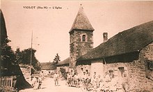
- Church of the Nativity of the Virgin Mary ( Église de la Vierge-en-sa-Nativité )
- Notre-Dame-des-Bois chapel and numerous crosses on the “Way of the Cross” from Violot to this chapel
- Croix des Montants , floor cross
- Fallen memorial
Economy and Infrastructure
Five farms are located in Violot (grain cultivation, dairy farming, cattle breeding).
In the Bois de Guyotte forest, in the south-east of the municipality of Violot, there is an underground military fuel depot operated by ODC Trapil .
25 km west of Violot there is a connection to the Autoroute A31 . The railway line from Is-sur-Tille to Chalindrey ( Ligne d'Is-sur-Tille à Culmont-Chalindrey ) runs through the neighboring communities of Le Pailly and Chalindrey . The nearest train station is five kilometers north of Violot in Chalindrey on the Paris – Mulhouse line .
supporting documents
- ↑ Violot on cassini.ehess.fr
- ↑ Violot on INSEE
- ↑ Le Pailly on cassini.ehess.fr
- ↑ Farms on annuaire-mairie.fr


