Coublanc (Haute-Marne)
| Coublanc | ||
|---|---|---|

|
|
|
| region | Grand Est | |
| Department | Haute-Marne | |
| Arrondissement | Langres | |
| Canton | Villegusien-le-Lac | |
| Community association | Auberive, Vingeanne et Montsaugeonnais | |
| Coordinates | 47 ° 42 ' N , 5 ° 28' E | |
| height | 237-367 m | |
| surface | 19.19 km 2 | |
| Residents | 117 (January 1, 2017) | |
| Population density | 6 inhabitants / km 2 | |
| Post Code | 52500 | |
| INSEE code | 52145 | |
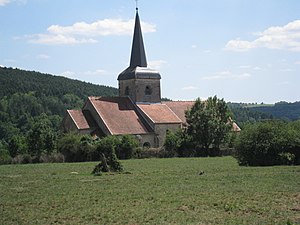
 Peter and Paul Church in Coublanc |
||
Coublanc is a French commune with 117 inhabitants (as of January 1, 2017) in the Haute-Marne department in the Grand Est region .
geography
Coublanc is located on the south-eastern edge of the Champagne-Ardenne region in the Langres arrondissement near the border with the neighboring region of Franche-Comté . The Haute-Saône department borders directly on the municipality. The Salon River runs east of the municipality's capital. The departmental roads D7 and D122 cross here.
history
Coublanc is an old town. It is a stage on the Via Francigena . The population has been declining since the French Revolution . While around 1800 there were still 500 inhabitants, the number of inhabitants decreased to less than 200 after the Second World War.
Attractions
- Église Saint-Pierre et Saint-Paul , 12th century church - Monument historique
- Lanterne des Morts , funeral lamp from 1537 - Monument historique
Web links
Commons : Coublanc - collection of images, videos and audio files
Individual evidence
- ↑ Église Saint-Pierre et Saint-Paul in the Base Mérimée of the French Ministry of Culture (French)
- ↑ Lanterne des Morts in the Base Mérimée of the French Ministry of Culture (French)
