
Enfonvelle
| Enfonvelle | ||
|---|---|---|
|
||
| region | Grand Est | |
| Department | Haute-Marne | |
| Arrondissement | Langres | |
| Canton | Bourbonne-les-Bains | |
| Community association | Pays de Chalindrey, de Vannier Amance et de la Région de Bourbonne-les-Bains | |
| Coordinates | 47 ° 56 ' N , 5 ° 52' E | |
| height | 237-332 m | |
| surface | 12.40 km 2 | |
| Residents | 68 (January 1, 2017) | |
| Population density | 5 inhabitants / km 2 | |
| Post Code | 52400 | |
| INSEE code | 52185 | |

Enfonvelle is a French commune with 68 inhabitants (as of January 1, 2017) in the Haute-Marne department in the Grand Est region ; it belongs to the Arrondissement of Langres .
geography
Enfonvelle is the easternmost commune of the Haute-Marne department. It is located on the Apance , around 58 kilometers east-southeast of the city of Chaumont in the southeast of the Haute-Marne department on the border with the Vosges and Haute-Saône departments .
history
Until 1789, the municipality was part of the Bailliage de Langres within the province of Champagne . The mechanization of agriculture led to heavy emigration in the late 19th and 20th centuries. The place was historically part of the Bailliage de Langres within the province of Champagne. Enfonvelle was part of the Bourbonne district from 1793 to 1801. Also from 1793 to 1801 to the canton of Fresnes-sur-Apance and from 1801 to the canton of Bourbonne-les-Bains .
Population development
| year | 1962 | 1968 | 1975 | 1982 | 1990 | 1999 | 2006 | 2012 | ||||||||
| Residents | 191 | 175 | 139 | 134 | 119 | 104 | 85 | 75 | ||||||||
| Sources: Cassini and INSEE | ||||||||||||||||
Attractions
- Saint-Léger village church from 1830
- Chapelle de l'Orme chapel
- Lavoir (wash house)
- five wayside crosses (Crois Robillet, la Croix Bois, Croix Robillet, Croix des Ormes and a cross at the northwest exit of the village)
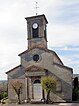
Saint-Léger village church

Lavoir of Enfonvelle

Meetinghouse (Mairie) of Enfonvelle


